
Fyn topographic map
Interactive map
Click on the map to display elevation.
About this map
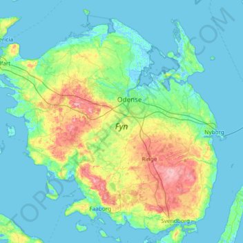
Name: Fyn topographic map, elevation, terrain.
Location: Fyn, Region of Southern Denmark, Denmark (55.02660 9.67709 55.64685 10.85612)
Average elevation: 19 m
Minimum elevation: -6 m
Maximum elevation: 121 m
Other topographic maps
Click on a map to view its topography, its elevation and its terrain.
Haderslev
Denmark > Region of Southern Denmark
Haderslev, Haderslev Municipality, Region of Southern Denmark, 6100, Denmark
Average elevation: 33 m
Odense
Denmark > Region of Southern Denmark > Odense
Odense, Odense Kommune, Region of Southern Denmark, 5000, Denmark
Average elevation: 30 m
Als
Denmark > Region of Southern Denmark
Als, Sønderborg Municipality, Region of Southern Denmark, Denmark
Average elevation: 8 m