Geolocate

Mold topographic map

Click on the map to display elevation.

About this map

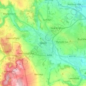
Name: Mold topographic map, elevation, terrain.

Location: Mold, Flintshire, Wales, CH7 1ER, United Kingdom (53.12663 -3.18142 53.20663 -3.10142)

Average elevation: 165 m

Minimum elevation: 71 m

Maximum elevation: 360 m

Other topographic maps

Click on a map to view its topography, its elevation and its terrain.

Wepre Park

United Kingdom > Wales > Flintshire > Connah's Quay

Average elevation: 46 m

Gear up for your next adventure:

🩰Hiking Binoculars - See long distances on trails
🔭Laser Distance Meters - Professional precision measuring for site surveys
🛶Waterproof Dry Bags - Keep electronics and clothes dry during wet treks
🔪Multi‑Tools & Knives - Versatile tools for outdoor tasks
🧤Thermal Gloves - Warm gloves for cold weather

As an Amazon Associate, this site earns from qualifying purchases at no extra cost to you.