
Thank you for supporting this site ❤️
Make a donation
Make a donation
Gear up for your next adventure:
As an Amazon Associate, this site earns from qualifying purchases at no extra cost to you.
Temecula topographic map
Click on the map to display elevation.
Thank you for supporting this site ❤️
Make a donation
Make a donation
Gear up for your next adventure:
As an Amazon Associate, this site earns from qualifying purchases at no extra cost to you.
About this map
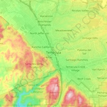
Name: Temecula topographic map, elevation, terrain.
Location: Temecula, Riverside County, California, United States (33.43213 -117.20669 33.55463 -117.05487)
Average elevation: 387 m
Minimum elevation: 155 m
Maximum elevation: 726 m
Thank you for supporting this site ❤️
Make a donation
Make a donation
Gear up for your next adventure:
As an Amazon Associate, this site earns from qualifying purchases at no extra cost to you.
Other topographic maps
Click on a map to view its topography, its elevation and its terrain.
Foster Lake
United States > California > Riverside County > Idyllwild-Pine Cove
Average elevation: 1,832 m