
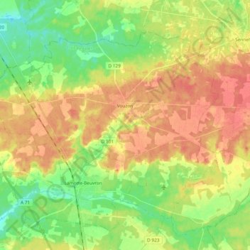
Vouzon topographic map
Interactive map
Click on the map to display elevation.
About this map
Name: Vouzon topographic map, elevation, terrain.
Average elevation: 126 m
Minimum elevation: 101 m
Maximum elevation: 150 m
Other topographic maps
Click on a map to view its topography, its elevation and its terrain.
Le Loup Pendu
France > Centre-Val de Loire > Loir-et-Cher > La Chapelle-Vendômoise
Le Loup Pendu, La Chapelle-Vendômoise, Blois, Loir-et-Cher, Centre-Val de Loire, France métropolitaine, 41330, France
Average elevation: 117 m
Blois
France > Centre-Val de Loire > Loir-et-Cher
Blois, Loir-et-Cher, Centre-Val de Loire, France métropolitaine, 41000, France
Average elevation: 95 m
Faverolle
France > Centre-Val de Loire > Loir-et-Cher > La Ferté-Imbault
Faverolle, La Ferté-Imbault, Romorantin-Lanthenay, Loir-et-Cher, Centre-Val de Loire, France métropolitaine, 41300, France
Average elevation: 116 m
Naveil
France > Centre-Val de Loire > Loir-et-Cher
Naveil, Vendôme, Loir-et-Cher, Centre-Val de Loire, France métropolitaine, 41100, France
Average elevation: 103 m
Bois Fuseau
France > Centre-Val de Loire > Loir-et-Cher > Villeherviers
Bois Fuseau, Villeherviers, Romorantin-Lanthenay, Loir-et-Cher, Centre-Val de Loire, France métropolitaine, 41200, France
Average elevation: 97 m
Les Monceaux
France > Centre-Val de Loire > Loir-et-Cher > Saint-Sulpice-de-Pommeray
Les Monceaux, Saint-Sulpice-de-Pommeray, Blois, Loir-et-Cher, Centre-Val de Loire, France métropolitaine, 41000, France
Average elevation: 116 m
Cormenon
France > Centre-Val de Loire > Loir-et-Cher
Cormenon, Vendôme, Loir-et-Cher, Centre-Val de Loire, France métropolitaine, 41170, France
Average elevation: 139 m
Suèvres
France > Centre-Val de Loire > Loir-et-Cher
Suèvres, Blois, Loir-et-Cher, Centre-Val de Loire, France métropolitaine, 41500, France
Average elevation: 97 m
Cheverny
France > Centre-Val de Loire > Loir-et-Cher
Cheverny, Blois, Loir-et-Cher, Centre-Val de Loire, France métropolitaine, 41700, France
Average elevation: 99 m
Chenillé
France > Centre-Val de Loire > Loir-et-Cher > Troo > Trôo
Chenillé, Trôo, Troo, Vendôme, Loir-et-Cher, Centre-Val de Loire, France métropolitaine, 41800, France
Average elevation: 107 m
Chouzy-sur-Cisse
France > Centre-Val de Loire > Loir-et-Cher > Valloire-sur-Cisse
Chouzy-sur-Cisse, Valloire-sur-Cisse, Blois, Loir-et-Cher, Centre-Val de Loire, France métropolitaine, 41150, France
Average elevation: 85 m
Thoré-la-Rochette
France > Centre-Val de Loire > Loir-et-Cher
Thoré-la-Rochette, Vendôme, Loir-et-Cher, Centre-Val de Loire, France métropolitaine, 41100, France
Average elevation: 94 m
Le Bourg
France > Centre-Val de Loire > Loir-et-Cher > Pierrefitte-sur-Sauldre
Le Bourg, Pierrefitte-sur-Sauldre, Romorantin-Lanthenay, Loir-et-Cher, Centre-Val de Loire, France métropolitaine, 41300, France
Average elevation: 124 m
La Chatelet
France > Centre-Val de Loire > Loir-et-Cher > Sainte-Anne
La Chatelet, Sainte-Anne, Vendôme, Loir-et-Cher, Centre-Val de Loire, France métropolitaine, 41100, France
Average elevation: 123 m
Le Temple
France > Centre-Val de Loire > Loir-et-Cher
Le Temple, Vendôme, Loir-et-Cher, Centre-Val de Loire, France métropolitaine, 41170, France
Average elevation: 177 m
Abelets
France > Centre-Val de Loire > Loir-et-Cher > Romorantin-Lanthenay
Abelets, Romorantin-Lanthenay, Loir-et-Cher, Centre-Val de Loire, France métropolitaine, 41200, France
Average elevation: 97 m
Mennetou-sur-Cher
France > Centre-Val de Loire > Loir-et-Cher
Mennetou-sur-Cher, Romorantin-Lanthenay, Loir-et-Cher, Centre-Val de Loire, France métropolitaine, 41320, France
Average elevation: 112 m
Étang de Villiers
France > Centre-Val de Loire > Loir-et-Cher > Chaumont-sur-Tharonne
Étang de Villiers, Chaumont-sur-Tharonne, Romorantin-Lanthenay, Loir-et-Cher, Centre-Val de Loire, France métropolitaine, 41600, France
Average elevation: 120 m
Le Poislay
France > Centre-Val de Loire > Loir-et-Cher
Le Poislay, Vendôme, Loir-et-Cher, Centre-Val de Loire, France métropolitaine, 41270, France
Average elevation: 168 m
Mur-de-Sologne
France > Centre-Val de Loire > Loir-et-Cher
Mur-de-Sologne, Romorantin-Lanthenay, Loir-et-Cher, Centre-Val de Loire, France métropolitaine, 41230, France
Average elevation: 108 m
Les Tirelles
France > Centre-Val de Loire > Loir-et-Cher > Busloup
Les Tirelles, Busloup, Vendôme, Loir-et-Cher, Centre-Val de Loire, France métropolitaine, 41160, France
Average elevation: 137 m
Clos de la Malicorne
France > Centre-Val de Loire > Loir-et-Cher > Romorantin-Lanthenay
Clos de la Malicorne, Romorantin-Lanthenay, Loir-et-Cher, Centre-Val de Loire, France métropolitaine, 41200, France
Average elevation: 98 m
41130
France > Centre-Val de Loire > Loir-et-Cher > Selles-sur-Cher
41130, Selles-sur-Cher, Romorantin-Lanthenay, Loir-et-Cher, Centre-Val de Loire, France métropolitaine, France
Average elevation: 84 m
Chissay-en-Touraine
France > Centre-Val de Loire > Loir-et-Cher
Chissay-en-Touraine, Romorantin-Lanthenay, Loir-et-Cher, Centre-Val de Loire, France métropolitaine, 41400, France
Average elevation: 116 m
La Fosse
France > Centre-Val de Loire > Loir-et-Cher > Saint-Martin-des-Bois
La Fosse, Saint-Martin-des-Bois, Vendôme, Loir-et-Cher, Centre-Val de Loire, France métropolitaine, 41800, France
Average elevation: 138 m
Villeherviers
France > Centre-Val de Loire > Loir-et-Cher
Villeherviers, Romorantin-Lanthenay, Loir-et-Cher, Centre-Val de Loire, France métropolitaine, 41200, France
Average elevation: 99 m
Contres
France > Centre-Val de Loire > Loir-et-Cher > Le Controis-en-Sologne
Contres, Le Controis-en-Sologne, Romorantin-Lanthenay, Loir-et-Cher, Centre-Val de Loire, France métropolitaine, 41700, France
Average elevation: 107 m
Chémery
France > Centre-Val de Loire > Loir-et-Cher
Chémery, Romorantin-Lanthenay, Loir-et-Cher, Centre-Val de Loire, France métropolitaine, 41700, France
Average elevation: 106 m
Gièvres
France > Centre-Val de Loire > Loir-et-Cher
Gièvres, Romorantin-Lanthenay, Loir-et-Cher, Centre-Val de Loire, France métropolitaine, 41130, France
Average elevation: 91 m
Villefranche-sur-Cher
France > Centre-Val de Loire > Loir-et-Cher
Villefranche-sur-Cher, Romorantin-Lanthenay, Loir-et-Cher, Centre-Val de Loire, France métropolitaine, 41200, France
Average elevation: 102 m
Cellettes
France > Centre-Val de Loire > Loir-et-Cher
Cellettes, Blois, Loir-et-Cher, Centre-Val de Loire, France métropolitaine, 41120, France
Average elevation: 92 m
Jardin Saint-Gilles Roseraie
France > Centre-Val de Loire > Loir-et-Cher > Montoire-sur-le-Loir > Saint-Oustrille
Jardin Saint-Gilles Roseraie, Saint-Oustrille, Montoire-sur-le-Loir, Vendôme, Loir-et-Cher, Centre-Val de Loire, France métropolitaine, 41800, France
Average elevation: 91 m
Chitenay
France > Centre-Val de Loire > Loir-et-Cher
Chitenay, Blois, Loir-et-Cher, Centre-Val de Loire, France métropolitaine, 41120, France
Average elevation: 94 m
Onzain
France > Centre-Val de Loire > Loir-et-Cher > Veuzain-sur-Loire
Onzain, Veuzain-sur-Loire, Blois, Loir-et-Cher, Centre-Val de Loire, France métropolitaine, 41150, France
Average elevation: 91 m
Peraclos
France > Centre-Val de Loire > Loir-et-Cher > Le Controis-en-Sologne > Les Aunaux
Peraclos, Les Aunaux, Feings, Le Controis-en-Sologne, Romorantin-Lanthenay, Loir-et-Cher, Centre-Val de Loire, France métropolitaine, 41120, France
Average elevation: 95 m
Pierrefitte-sur-Sauldre
France > Centre-Val de Loire > Loir-et-Cher
Pierrefitte-sur-Sauldre, Romorantin-Lanthenay, Loir-et-Cher, Centre-Val de Loire, France métropolitaine, 41300, France
Average elevation: 130 m
Aiguevives
France > Centre-Val de Loire > Loir-et-Cher > Faverolles-sur-Cher
Aiguevives, Faverolles-sur-Cher, Romorantin-Lanthenay, Loir-et-Cher, Centre-Val de Loire, France métropolitaine, 41400, France
Average elevation: 139 m
Prés de Saint-Gervais
France > Centre-Val de Loire > Loir-et-Cher > Les Roches-l'Évêque
Prés de Saint-Gervais, Les Roches-l'Évêque, Vendôme, Loir-et-Cher, Centre-Val de Loire, France métropolitaine, 41800, France
Average elevation: 100 m
Vendôme
France > Centre-Val de Loire > Loir-et-Cher
Vendôme, Loir-et-Cher, Centre-Val de Loire, France métropolitaine, 41100, France
Average elevation: 110 m
Blois-Vienne
France > Centre-Val de Loire > Loir-et-Cher > Blois
Blois-Vienne, Blois, Loir-et-Cher, Centre-Val de Loire, France métropolitaine, 41000, France
Average elevation: 80 m
Lamotte-Beuvron
France > Centre-Val de Loire > Loir-et-Cher
Lamotte-Beuvron, Romorantin-Lanthenay, Loir-et-Cher, Centre-Val de Loire, France métropolitaine, 41600, France
Average elevation: 125 m
Faverolles-sur-Cher
France > Centre-Val de Loire > Loir-et-Cher
Faverolles-sur-Cher, Romorantin-Lanthenay, Loir-et-Cher, Centre-Val de Loire, France métropolitaine, 41400, France
Average elevation: 104 m
Les Granges
France > Centre-Val de Loire > Loir-et-Cher > Blois
Les Granges, Blois, Loir-et-Cher, Centre-Val de Loire, France métropolitaine, 41000, France
Average elevation: 100 m
Sargé-sur-Braye
France > Centre-Val de Loire > Loir-et-Cher
Sargé-sur-Braye, Vendôme, Loir-et-Cher, Centre-Val de Loire, France métropolitaine, 41170, France
Average elevation: 139 m
Bellevue
France > Centre-Val de Loire > Loir-et-Cher > Seigy
Bellevue, Seigy, Romorantin-Lanthenay, Loir-et-Cher, Centre-Val de Loire, France métropolitaine, 41110, France
Average elevation: 93 m
Pouillé
France > Centre-Val de Loire > Loir-et-Cher
Pouillé, Romorantin-Lanthenay, Loir-et-Cher, Centre-Val de Loire, France métropolitaine, 41110, France
Average elevation: 108 m
Bourg de Lassay
France > Centre-Val de Loire > Loir-et-Cher > Lassay-sur-Croisne
Bourg de Lassay, Lassay-sur-Croisne, Romorantin-Lanthenay, Loir-et-Cher, Centre-Val de Loire, France métropolitaine, 41230, France
Average elevation: 100 m
Langon-sur-Cher
France > Centre-Val de Loire > Loir-et-Cher
Langon-sur-Cher, Romorantin-Lanthenay, Loir-et-Cher, Centre-Val de Loire, France métropolitaine, 41320, France
Average elevation: 108 m
Nouan-le-Fuzelier
France > Centre-Val de Loire > Loir-et-Cher
Nouan-le-Fuzelier, Romorantin-Lanthenay, Loir-et-Cher, Centre-Val de Loire, France métropolitaine, 41600, France
Average elevation: 119 m
Le Gatinais
France > Centre-Val de Loire > Loir-et-Cher > Souvigny-en-Sologne
Le Gatinais, La Laurendière, Souvigny-en-Sologne, Romorantin-Lanthenay, Loir-et-Cher, Centre-Val de Loire, France métropolitaine, 41600, France
Average elevation: 146 m