
Thank you for supporting this site ❤️
Make a donation
Make a donation
Gear up for your next adventure:
As an Amazon Associate, this site earns from qualifying purchases at no extra cost to you.
Quincy topographic map
Click on the map to display elevation.
Thank you for supporting this site ❤️
Make a donation
Make a donation
Gear up for your next adventure:
As an Amazon Associate, this site earns from qualifying purchases at no extra cost to you.
About this map
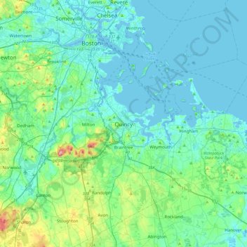
Name: Quincy topographic map, elevation, terrain.
Location: Quincy, Norfolk County, Massachusetts, 02169, United States (42.09099 -71.16374 42.41099 -70.84374)
Average elevation: 28 m
Minimum elevation: -5 m
Maximum elevation: 186 m
Thank you for supporting this site ❤️
Make a donation
Make a donation
Gear up for your next adventure:
As an Amazon Associate, this site earns from qualifying purchases at no extra cost to you.
Other topographic maps
Click on a map to view its topography, its elevation and its terrain.
Blue Hills Reservation
United States > Massachusetts > Norfolk County > Quincy
Average elevation: 48 m