
Jeju Island topographic map
Interactive map
Click on the map to display elevation.
About this map
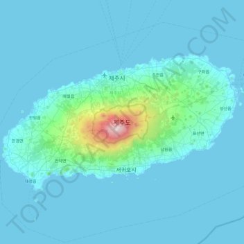
Name: Jeju Island topographic map, elevation, terrain.
Location: Jeju Island, Jeju, South Korea (33.19505 126.16064 33.56564 126.94701)
Average elevation: 98 m
Minimum elevation: -1 m
Maximum elevation: 1,923 m
Other topographic maps
Click on a map to view its topography, its elevation and its terrain.
수원화성
수원화성, Hwaseomun-ro 17beon-gil, 행리단길, 팔달구, Suwon-si, 16251, South Korea
Average elevation: 63 m
Goseong-ri
Goseong-ri, Seogwipo-si, Jeju, 63640, South Korea
Average elevation: 19 m
Sinyang-ri
Sinyang-ri, Seogwipo-si, Jeju, 63641, South Korea
Average elevation: 18 m
Dokdo Island
South Korea > Ulleung-gun > Dokdo-ri
Dokdo Island, Dokdo-ri, Ulleung-gun, North Gyeongsang, South Korea
Average elevation: 0 m
Simgok-ri
South Korea > Muju-gun > Seolcheon-myeon
Simgok-ri, Seolcheon-myeon, Muju-gun, Jeonbuk State, South Korea
Average elevation: 794 m
Jusan
Jusan, Gokseong-gun, South Jeolla, 57502, South Korea
Average elevation: 121 m
27312
South Korea > Chungju-si > Sinman-ri
27312, Sinman-ri, Chungju-si, North Chungcheong, South Korea
Average elevation: 137 m
Seokjeon-ri
South Korea > Chilgok-gun > Waegwan-eup
Seokjeon-ri, Waegwan-eup, Chilgok-gun, North Gyeongsang, 39889, South Korea
Average elevation: 55 m
27712
South Korea > Eumseong-gun > Daejang-ri
27712, Daejang-ri, Eumseong-gun, North Chungcheong, South Korea
Average elevation: 144 m
16055
16055, Ojeon-dong, Uiwang-si, Gyeonggi, South Korea
Average elevation: 95 m
16037
16037, Naeson 1-dong, Uiwang-si, Gyeonggi, South Korea
Average elevation: 98 m
Jeungpyeong-eup
Jeungpyeong-eup, Jeungpyeong-gun, North Chungcheong, South Korea
Average elevation: 121 m
Waya-ri
Waya-ri, Nonsan-si, South Chungcheong, 32998, South Korea
Average elevation: 24 m
Dongnam-gu
Dongnam-gu, Cheonan-si, South Chungcheong, South Korea
Average elevation: 133 m
Gwonseon-gu
Gwonseon-gu, Suwon-si, Gyeonggi, South Korea
Average elevation: 47 m
Jangpyeong-ri
South Korea > Pyeongchang-gun > Yongpyeong-myeon
Jangpyeong-ri, Yongpyeong-myeon, Pyeongchang-gun, Gangwon State, 25315, South Korea
Average elevation: 609 m
Samgot-ri
South Korea > Yeoncheon-gun > Jung-myeon
Samgot-ri, Jung-myeon, Yeoncheon-gun, Gyeonggi, 11004, South Korea
Average elevation: 93 m
Panoramic view point
Panoramic view point, 비법정탐방로, Daepo-dong, Sokcho-si, Gangwon State, 24903, South Korea
Average elevation: 541 m
Hwado-myeon
South Korea > Ganghwa-gun > Incheon
Hwado-myeon, Ganghwa-gun, Incheon, South Korea
Average elevation: 28 m
Turczaninow Hornbeam Tree at Chamseongdan Altar
South Korea > Ganghwa-gun > Incheon > Hwado-myeon
Turczaninow Hornbeam Tree at Chamseongdan Altar, 당근로, Hwado-myeon, Ganghwa-gun, Incheon, 23060, South Korea
Average elevation: 155 m
Hyangnam
Hyangnam, Hwaseong-si, Gyeonggi, 18600, South Korea
Average elevation: 48 m
Hail-myeon
Hail-myeon, Goseong-gun, South Gyeongsang, 52956, South Korea
Average elevation: 89 m
Bukhansan (Baikundae)
Bukhansan (Baikundae), Goyang-si, Gyeonggi, 01000, South Korea
Average elevation: 400 m
Gurun-ri
South Korea > Hongcheon-gun > Hwachon-myeon
Gurun-ri, Hwachon-myeon, Hongcheon-gun, Gangwon State, 25158, South Korea
Average elevation: 298 m
Hwachon-myeon
Hwachon-myeon, Hongcheon-gun, Gangwon State, South Korea
Average elevation: 379 m
Hoedong-ri
South Korea > Pyeongchang-gun > Mitan-myeon
Hoedong-ri, Mitan-myeon, Pyeongchang-gun, Gangwon State, 25380, South Korea
Average elevation: 710 m