
Make a donation
Gear up for your next adventure:
As an Amazon Associate, this site earns from qualifying purchases at no extra cost to you.
Amions topographic map
Click on the map to display elevation.
Make a donation
Gear up for your next adventure:
As an Amazon Associate, this site earns from qualifying purchases at no extra cost to you.
About this map
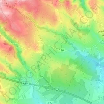
Name: Amions topographic map, elevation, terrain.
Average elevation: 435 m
Minimum elevation: 359 m
Maximum elevation: 531 m
Make a donation
Gear up for your next adventure:
As an Amazon Associate, this site earns from qualifying purchases at no extra cost to you.
Other topographic maps
Click on a map to view its topography, its elevation and its terrain.
Buissant
France > Auvergne-Rhône-Alpes > Loire > Vézelin-sur-Loire > Saint-Paul-de-Vézelin
Average elevation: 390 m
Les Roches
France > Auvergne-Rhône-Alpes > Loire > Vézelin-sur-Loire > Amions
Average elevation: 432 m
Pêt de l'âne
France > Auvergne-Rhône-Alpes > Loire > Vézelin-sur-Loire > Dancé
Average elevation: 425 m