
Make a donation
Gear up for your next adventure:
As an Amazon Associate, this site earns from qualifying purchases at no extra cost to you.
Catubig topographic map
Click on the map to display elevation.
Make a donation
Gear up for your next adventure:
As an Amazon Associate, this site earns from qualifying purchases at no extra cost to you.
Catubig
Another tale was mentioned that the name Catubig was also a product of a 'word compact' between Americans and Filipinos. It was stated that an American surveyors saw a cat sunbathing by rolling along the grassy edge of the brook. They then approached a young lady who was doing her laundry and asked, “What is that, cat?” The lass, hardly seeing the cat which was in higher elevation, and not knowing what the foreigners were asking about simply responded, “Tubig,” meaning the water of the brook.
Make a donation
Gear up for your next adventure:
As an Amazon Associate, this site earns from qualifying purchases at no extra cost to you.
About this map
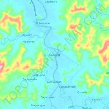
Name: Catubig topographic map, elevation, terrain.
Location: Catubig, Northern Samar, Eastern Visayas, Philippines (12.36787 125.01444 12.44787 125.09444)
Average elevation: 41 m
Minimum elevation: 0 m
Maximum elevation: 201 m
Make a donation
Gear up for your next adventure:
As an Amazon Associate, this site earns from qualifying purchases at no extra cost to you.