
Make a donation
Gear up for your next adventure:
As an Amazon Associate, this site earns from qualifying purchases at no extra cost to you.
Dinkelberg topographic map
Click on the map to display elevation.
Make a donation
Gear up for your next adventure:
As an Amazon Associate, this site earns from qualifying purchases at no extra cost to you.
Dinkelberg
Zu den Bergen, Erhebungen und deren Ausläufern des Dinkelbergs gehören – sortiert nach Höhe in Meter (m) über Normalhöhennull (NHN; D) und Meter über Meer (m ü. M.; CH).
Make a donation
Gear up for your next adventure:
As an Amazon Associate, this site earns from qualifying purchases at no extra cost to you.
About this map
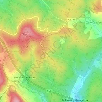
Name: Dinkelberg topographic map, elevation, terrain.
Average elevation: 414 m
Minimum elevation: 337 m
Maximum elevation: 497 m
Make a donation
Gear up for your next adventure:
As an Amazon Associate, this site earns from qualifying purchases at no extra cost to you.
Other topographic maps
Click on a map to view its topography, its elevation and its terrain.
79618
Deutschland > Baden-Württemberg > Landkreis Lörrach > Rheinfelden (Baden) > Niedereichsel
Average elevation: 374 m