
Dickson County topographic map
Interactive map
Click on the map to display elevation.
About this map
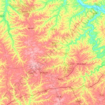
Name: Dickson County topographic map, elevation, terrain.
Location: Dickson County, Tennessee, United States of America (35.96083 -87.56629 36.33515 -87.14801)
Average elevation: 211 m
Minimum elevation: 113 m
Maximum elevation: 293 m
Other topographic maps
Click on a map to view its topography, its elevation and its terrain.
Gatlinburg
United States of America > Tennessee > Gatlinburg
Gatlinburg, Sevier County, Tennessee, United States of America
Average elevation: 577 m