
Make a donation
Gear up for your next adventure:
As an Amazon Associate, this site earns from qualifying purchases at no extra cost to you.
Villamaría topographic map
Click on the map to display elevation.
Make a donation
Gear up for your next adventure:
As an Amazon Associate, this site earns from qualifying purchases at no extra cost to you.
Villamaría
Las variaciones altitudinales otorgan al municipio de Villamaría la posibilidad de tener tres pisos térmicos, identificados en microrregiones (zona alta o de páramo, zona media u hortofrutícula, zona baja cafetera), con un potencial productivo y turístico.
Make a donation
Gear up for your next adventure:
As an Amazon Associate, this site earns from qualifying purchases at no extra cost to you.
About this map
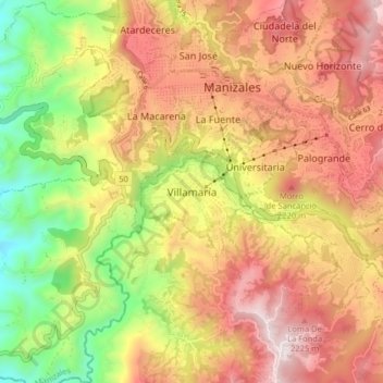
Name: Villamaría topographic map, elevation, terrain.
Location: Villamaría, Centrosur, Caldas, 176001, Colombia (5.00497 -75.55513 5.08497 -75.47513)
Average elevation: 1,947 m
Minimum elevation: 1,401 m
Maximum elevation: 2,420 m
Make a donation
Gear up for your next adventure:
As an Amazon Associate, this site earns from qualifying purchases at no extra cost to you.
Other topographic maps
Click on a map to view its topography, its elevation and its terrain.