
Make a donation
Gear up for your next adventure:
As an Amazon Associate, this site earns from qualifying purchases at no extra cost to you.
Hiiumaa topographic map
Click on the map to display elevation.
Make a donation
Gear up for your next adventure:
As an Amazon Associate, this site earns from qualifying purchases at no extra cost to you.
About this map
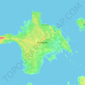
Name: Hiiumaa topographic map, elevation, terrain.
Location: Hiiumaa, Estonia (58.68687 22.03855 59.09346 23.06944)
Average elevation: 3 m
Minimum elevation: -1 m
Maximum elevation: 67 m
Make a donation
Gear up for your next adventure:
As an Amazon Associate, this site earns from qualifying purchases at no extra cost to you.
Other topographic maps
Click on a map to view its topography, its elevation and its terrain.
Estonia
Estonia lies on the eastern shores of the Baltic Sea immediately across the Gulf of Finland, on the level northwestern part of the rising East European platform between 57.3° and 59.5° N and 21.5° and 28.1° E. Average elevation reaches only 50 metres (164 ft) and the country's highest point is the Suur…
Average elevation: 142 m