
Make a donation
Gear up for your next adventure:
As an Amazon Associate, this site earns from qualifying purchases at no extra cost to you.
Madison topographic map
Click on the map to display elevation.
Make a donation
Gear up for your next adventure:
As an Amazon Associate, this site earns from qualifying purchases at no extra cost to you.
Madison
According to the United States Census Bureau, the city has an area of 94.03 square miles (243.54 km2), of which 76.79 square miles (198.89 km2) is land and 17.24 square miles (44.65 km2) is water. The city's lowest elevation is the intersection of Regas Road and Corporate Drive on the east side, at 836.9 ft (255.1 m). The highest elevation is located along Pleasant View Road on the far west side of the city, atop a portion of a terminal moraine of the Green Bay Lobe of the Wisconsin glaciation, at 1,190 ft (360 m).
Make a donation
Gear up for your next adventure:
As an Amazon Associate, this site earns from qualifying purchases at no extra cost to you.
About this map
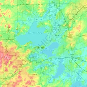
Name: Madison topographic map, elevation, terrain.
Location: Madison, Dane County, Wisconsin, United States (42.99815 -89.57166 43.17192 -89.23208)
Average elevation: 284 m
Minimum elevation: 256 m
Maximum elevation: 369 m
Make a donation
Gear up for your next adventure:
As an Amazon Associate, this site earns from qualifying purchases at no extra cost to you.
Other topographic maps
Click on a map to view its topography, its elevation and its terrain.
Make a donation
Gear up for your next adventure:
As an Amazon Associate, this site earns from qualifying purchases at no extra cost to you.
Isthmus Path Prairie Garden
United States > Wisconsin > Dane County > Madison
Average elevation: 262 m
Make a donation
Gear up for your next adventure:
As an Amazon Associate, this site earns from qualifying purchases at no extra cost to you.
Walking Iron County Park
United States > Wisconsin > Dane County > Town of Mazomanie
Average elevation: 236 m
Make a donation
Gear up for your next adventure:
As an Amazon Associate, this site earns from qualifying purchases at no extra cost to you.
Deansville Wildlife Area
United States > Wisconsin > Dane County > Town of York
Average elevation: 264 m