
Make a donation
Gear up for your next adventure:
As an Amazon Associate, this site earns from qualifying purchases at no extra cost to you.
Aalen topographic map
Click on the map to display elevation.
Make a donation
Gear up for your next adventure:
As an Amazon Associate, this site earns from qualifying purchases at no extra cost to you.
Aalen
Da sich das Stadtgebiet Aalens über das Albvorland, die Voralb, den Albuch und über das Härtsfeld erstreckt und dabei insgesamt 355 Höhenmeter Unterschied zwischen tiefstem und höchstem Punkt überwindet, ist das Klima von Stadtbezirk zu Stadtbezirk verschieden.
Make a donation
Gear up for your next adventure:
As an Amazon Associate, this site earns from qualifying purchases at no extra cost to you.
About this map
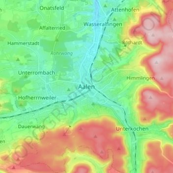
Name: Aalen topographic map, elevation, terrain.
Average elevation: 530 m
Minimum elevation: 409 m
Maximum elevation: 735 m
Make a donation
Gear up for your next adventure:
As an Amazon Associate, this site earns from qualifying purchases at no extra cost to you.