
Saint-Règle topographic map
Interactive map
Click on the map to display elevation.
About this map
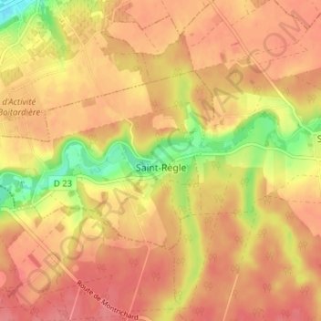
Name: Saint-Règle topographic map, elevation, terrain.
Average elevation: 101 m
Minimum elevation: 56 m
Maximum elevation: 122 m
Other topographic maps
Click on a map to view its topography, its elevation and its terrain.
La Cave Ravouée
France > Centre-Val de Loire > Indre-et-Loire > Épeigné-les-Bois
Average elevation: 113 m
La Chaume
France > Centre-Val de Loire > Indre-et-Loire > Sainte-Maure-de-Touraine
Average elevation: 95 m
Le Carroi
France > Centre-Val de Loire > Indre-et-Loire > Mazières-de-Touraine
Average elevation: 91 m
Les Quarts de Mosny
France > Centre-Val de Loire > Indre-et-Loire > Rochecorbon
Average elevation: 82 m
La Gaulterie
France > Centre-Val de Loire > Indre-et-Loire > Chemillé-sur-Indrois
Average elevation: 119 m
Étang de Beaune
France > Centre-Val de Loire > Indre-et-Loire > Ballan-Miré > Les Petites Hérissières
Average elevation: 89 m
La Vallée des Caves
France > Centre-Val de Loire > Indre-et-Loire > Rochecorbon
Average elevation: 110 m
Aux Fièvres les Caves
France > Centre-Val de Loire > Indre-et-Loire > Beaumont-en-Véron
Average elevation: 38 m
Le Petit Bouqueteau
France > Centre-Val de Loire > Indre-et-Loire > Chinon > La Roche Faucon
Average elevation: 70 m
Le Portail
France > Centre-Val de Loire > Indre-et-Loire > Saint-Étienne-de-Chigny
Average elevation: 80 m
Château de Villandry
France > Centre-Val de Loire > Indre-et-Loire > Villandry > Le Château
Average elevation: 64 m
Le Puy Mary
France > Centre-Val de Loire > Indre-et-Loire > Le Petit-Pressigny
Average elevation: 123 m
Château de Chenonceau
France > Centre-Val de Loire > Indre-et-Loire > Chenonceaux > Parc de Chenonceaux
Average elevation: 74 m
Saint-Sulpice
France > Centre-Val de Loire > Indre-et-Loire > Chambourg-sur-Indre
Average elevation: 90 m
La Tuilerie
France > Centre-Val de Loire > Indre-et-Loire > La Croix-en-Touraine
Average elevation: 74 m
La Grange du Bois
France > Centre-Val de Loire > Indre-et-Loire > Épeigné-les-Bois
Average elevation: 105 m
Les Bas de Sainte-Radegonde
France > Centre-Val de Loire > Indre-et-Loire > Chinon
Average elevation: 57 m
Les Quarts
France > Centre-Val de Loire > Indre-et-Loire > Montlouis-sur-Loire
Average elevation: 62 m
La Pièce du Thé
France > Centre-Val de Loire > Indre-et-Loire > La Croix-en-Touraine
Average elevation: 81 m
Les Métayries
France > Centre-Val de Loire > Indre-et-Loire > Betz-le-Château
Average elevation: 135 m
Le Pré des Dépends
France > Centre-Val de Loire > Indre-et-Loire > Sainte-Catherine-de-Fierbois
Average elevation: 113 m
La Fontaine de l'Ormeau
France > Centre-Val de Loire > Indre-et-Loire > La Croix-en-Touraine
Average elevation: 78 m
Perruches de la Martinière
France > Centre-Val de Loire > Indre-et-Loire > Veigné
Average elevation: 81 m
La Taille
France > Centre-Val de Loire > Indre-et-Loire > Saint-Nicolas-de-Bourgueil
Average elevation: 32 m
Saint-Hylaire
France > Centre-Val de Loire > Indre-et-Loire > Chemillé-sur-Dême
Average elevation: 105 m
Le Port de Nouatre
France > Centre-Val de Loire > Indre-et-Loire > Marcilly-sur-Vienne
Average elevation: 52 m
Les Terrasses de l'Aubrière
France > Centre-Val de Loire > Indre-et-Loire > La Membrolle-sur-Choisille
Average elevation: 83 m
La Haute Papinière
France > Centre-Val de Loire > Indre-et-Loire > Rilly-sur-Vienne
Average elevation: 68 m
Parc du Lac des Bretonnières
France > Centre-Val de Loire > Indre-et-Loire > Joué-lès-Tours > La Petite Carte
Average elevation: 85 m
Les Chauvelles
France > Centre-Val de Loire > Indre-et-Loire > Azay-le-Rideau > Lionnière
Average elevation: 81 m
Île de Porteau
France > Centre-Val de Loire > Indre-et-Loire > La Chapelle-sur-Loire
Average elevation: 34 m
La Grangette
France > Centre-Val de Loire > Indre-et-Loire > Montlouis-sur-Loire
Average elevation: 59 m