
Mitte topographic map
Interactive map
Click on the map to display elevation.
About this map
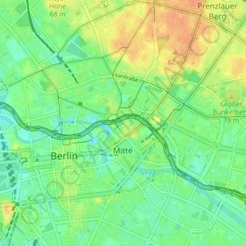
Name: Mitte topographic map, elevation, terrain.
Location: Mitte, Berlin, Germany (52.50404 13.36586 52.54041 13.42940)
Average elevation: 43 m
Minimum elevation: 26 m
Maximum elevation: 63 m
Other topographic maps
Click on a map to view its topography, its elevation and its terrain.
Treptower Park
Treptower Park, Alt-Treptow, Berlin, 12435, Germany
Average elevation: 37 m