
Penrhosfeilw topographic map
Interactive map
Click on the map to display elevation.
About this map
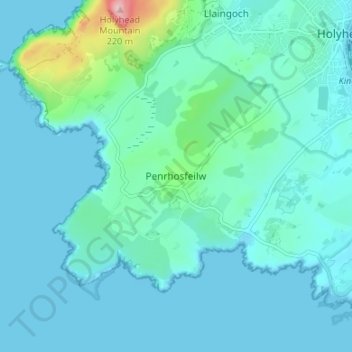
Name: Penrhosfeilw topographic map, elevation, terrain.
Average elevation: 27 m
Minimum elevation: -1 m
Maximum elevation: 217 m
Other topographic maps
Click on a map to view its topography, its elevation and its terrain.
Llanfihangel yn Nhowyn
United Kingdom > Wales > Isle of Anglesey > Caergeiliog
Llanfihangel yn Nhowyn, Llanfair-yn-Neubwll, Caergeiliog, Isle of Anglesey, Wales, LL65 3NB, United Kingdom
Average elevation: 13 m
Cefn-bach
United Kingdom > Wales > Isle of Anglesey > Llanddaniel Fab
Cefn-bach, Llanddaniel Fab, Isle of Anglesey, Wales, LL61 6EJ, United Kingdom
Average elevation: 33 m
Brynrefail
United Kingdom > Wales > Isle of Anglesey
Brynrefail, Isle of Anglesey, Wales, LL70 9PJ, United Kingdom
Average elevation: 49 m
Gaerwen
United Kingdom > Wales > Isle of Anglesey
Gaerwen, Isle of Anglesey, Wales, LL60 6BN, United Kingdom
Average elevation: 45 m
Tynygongl
United Kingdom > Wales > Isle of Anglesey
Tynygongl, Isle of Anglesey, Wales, LL74 8SD, United Kingdom
Average elevation: 61 m
Llanfechell
United Kingdom > Wales > Isle of Anglesey
Llanfechell, Isle of Anglesey, Wales, LL68 0PY, United Kingdom
Average elevation: 40 m
Holy Island
United Kingdom > Wales > Isle of Anglesey > Trearddur
Holy Island, Trearddur, Isle of Anglesey, Wales, United Kingdom
Average elevation: 9 m
Llyn Parc Mawr
United Kingdom > Wales > Isle of Anglesey > Newborough
Llyn Parc Mawr, Rhosyr, Newborough, Isle of Anglesey, Wales, United Kingdom
Average elevation: 10 m
Sling
United Kingdom > Wales > Isle of Anglesey > Beaumaris
Sling, Llanddona, Beaumaris, Isle of Anglesey, Wales, LL58 8TH, United Kingdom
Average elevation: 87 m
Rhosgoch
United Kingdom > Wales > Isle of Anglesey > Bodewryd
Rhosgoch, Rhosybol, Bodewryd, Isle of Anglesey, Wales, LL66 0AB, United Kingdom
Average elevation: 59 m
Llanrhyddlad
United Kingdom > Wales > Isle of Anglesey
Llanrhyddlad, Cylch-y-Garn, Isle of Anglesey, Wales, LL65 4HR, United Kingdom
Average elevation: 64 m
Bryngwran
United Kingdom > Wales > Isle of Anglesey
Bryngwran, Isle of Anglesey, Wales, LL65 3PT, United Kingdom
Average elevation: 28 m
Pentraeth
United Kingdom > Wales > Isle of Anglesey
Pentraeth, Isle of Anglesey, Wales, LL75 8AZ, United Kingdom
Average elevation: 50 m
Gwalchmai
United Kingdom > Wales > Isle of Anglesey
Gwalchmai, Isle of Anglesey, Wales, LL65 4RE, United Kingdom
Average elevation: 57 m
Holyhead
United Kingdom > Wales > Isle of Anglesey
Holyhead, Isle of Anglesey, Wales, LL65 1UN, United Kingdom
Average elevation: 10 m
Anglesey
United Kingdom > Wales > Isle of Anglesey
Anglesey, Isle of Anglesey, Wales, United Kingdom
Average elevation: 43 m
Bodffordd
United Kingdom > Wales > Isle of Anglesey
Bodffordd, Isle of Anglesey, Wales, LL77 7LQ, United Kingdom
Average elevation: 56 m
Broad Beach
United Kingdom > Wales > Isle of Anglesey > Rhosneigr > Llanfaelog
Broad Beach, Llanfaelog, Rhosneigr, Isle of Anglesey, Wales, United Kingdom
Average elevation: 5 m
Cemaes
United Kingdom > Wales > Isle of Anglesey > Cemaes
Cemaes, Isle of Anglesey, Wales, LL67 0EY, United Kingdom
Average elevation: 20 m
Llanfairpwllgwyngyll
United Kingdom > Wales > Isle of Anglesey
Llanfairpwllgwyngyll, Isle of Anglesey, Wales, LL61 5HY, United Kingdom
Average elevation: 45 m
Amlwch
United Kingdom > Wales > Isle of Anglesey
Amlwch, Isle of Anglesey, Wales, LL68 9EU, United Kingdom
Average elevation: 38 m
Llaingoch
United Kingdom > Wales > Isle of Anglesey > Llaingoch
Llaingoch, Isle of Anglesey, Wales, LL65 1LS, United Kingdom
Average elevation: 27 m
Llanrhwydrys
United Kingdom > Wales > Isle of Anglesey
Llanrhwydrys, Isle of Anglesey, Wales, LL67 0DY, United Kingdom
Average elevation: 15 m
Valley
United Kingdom > Wales > Isle of Anglesey
Valley, Isle of Anglesey, Wales, United Kingdom
Average elevation: 6 m
Llangefni
United Kingdom > Wales > Isle of Anglesey
Llangefni, Isle of Anglesey, Wales, LL77 7LR, United Kingdom
Average elevation: 47 m
Trearddur
United Kingdom > Wales > Isle of Anglesey
Trearddur, Isle of Anglesey, Wales, United Kingdom
Average elevation: 9 m
Llannerch-y-Medd
United Kingdom > Wales > Isle of Anglesey
Llannerch-y-Medd, Isle of Anglesey, Wales, United Kingdom
Average elevation: 66 m
Moelfre
United Kingdom > Wales > Isle of Anglesey > Brynrefail
Moelfre, Brynrefail, Isle of Anglesey, Wales, United Kingdom
Average elevation: 43 m
Menai Bridge
United Kingdom > Wales > Isle of Anglesey
Menai Bridge, Isle of Anglesey, Wales, LL59 5DG, United Kingdom
Average elevation: 58 m
Llanfachraeth
United Kingdom > Wales > Isle of Anglesey
Llanfachraeth, Isle of Anglesey, Wales, United Kingdom
Average elevation: 13 m
Llanddeusant
United Kingdom > Wales > Isle of Anglesey
Llanddeusant, Isle of Anglesey, Wales, LL65 4AD, United Kingdom
Average elevation: 40 m
Llangoed
United Kingdom > Wales > Isle of Anglesey
Llangoed, Isle of Anglesey, Wales, LL58 8NW, United Kingdom
Average elevation: 47 m
Rhosybol
United Kingdom > Wales > Isle of Anglesey
Rhosybol, Isle of Anglesey, Wales, LL68 9PU, United Kingdom
Average elevation: 65 m
Newborough
United Kingdom > Wales > Isle of Anglesey
Newborough, Isle of Anglesey, Wales, LL61 6SD, United Kingdom
Average elevation: 19 m
Dwyran
United Kingdom > Wales > Isle of Anglesey
Dwyran, Isle of Anglesey, Wales, LL61 6YF, United Kingdom
Average elevation: 17 m
Benllech
United Kingdom > Wales > Isle of Anglesey
Benllech, Isle of Anglesey, Wales, LL74 8UN, United Kingdom
Average elevation: 34 m
Llanfairpwllgwyngyll
United Kingdom > Wales > Isle of Anglesey > Llanfairpwllgwyngyll
Llanfairpwllgwyngyll, Isle of Anglesey, Wales, LL61, United Kingdom
Average elevation: 42 m