
Löhne topographic map
Interactive map
Click on the map to display elevation.
About this map
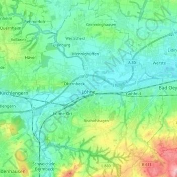
Name: Löhne topographic map, elevation, terrain.
Location: Löhne, Kreis Herford, Noordrijn-Westfalen, 32584, Duitsland (52.14977 8.66364 52.25193 8.78887)
Average elevation: 93 m
Minimum elevation: 44 m
Maximum elevation: 257 m
Other topographic maps
Click on a map to view its topography, its elevation and its terrain.
Hiddenhausen
Duitsland > Noordrijn-Westfalen > Kreis Herford
Hiddenhausen, Kreis Herford, Noordrijn-Westfalen, 32120, Duitsland
Average elevation: 92 m
Vlotho
Duitsland > Noordrijn-Westfalen > Kreis Herford
Vlotho, Kreis Herford, Noordrijn-Westfalen, 32602, Duitsland
Average elevation: 149 m
Kirchlengern
Duitsland > Noordrijn-Westfalen > Kreis Herford
Kirchlengern, Kreis Herford, Noordrijn-Westfalen, Duitsland
Average elevation: 80 m
Bonneberg
Duitsland > Noordrijn-Westfalen > Kreis Herford > Vlotho > Bonneberg
Bonneberg, Vlotho, Kreis Herford, Noordrijn-Westfalen, 32602, Duitsland
Average elevation: 150 m
Vlotho
Duitsland > Noordrijn-Westfalen > Kreis Herford > Vlotho
Vlotho, Kreis Herford, Noordrijn-Westfalen, 32602, Duitsland
Average elevation: 119 m
Herford-Stadt
Duitsland > Noordrijn-Westfalen > Kreis Herford
Herford-Stadt, Herford, Kreis Herford, Noordrijn-Westfalen, Duitsland
Average elevation: 91 m