
Make a donation
Gear up for your next adventure:
As an Amazon Associate, this site earns from qualifying purchases at no extra cost to you.
Todd Township topographic map
Click on the map to display elevation.
Make a donation
Gear up for your next adventure:
As an Amazon Associate, this site earns from qualifying purchases at no extra cost to you.
About this map
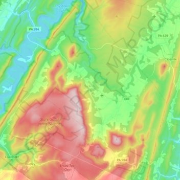
Name: Todd Township topographic map, elevation, terrain.
Average elevation: 425 m
Minimum elevation: 235 m
Maximum elevation: 713 m
Make a donation
Gear up for your next adventure:
As an Amazon Associate, this site earns from qualifying purchases at no extra cost to you.
Other topographic maps
Click on a map to view its topography, its elevation and its terrain.
Cold Spring
United States > Pennsylvania > Huntingdon County > Oneida Township
Average elevation: 256 m
Pemberton
United States > Pennsylvania > Huntingdon County > Spruce Creek Township
Average elevation: 309 m
Pennsylvania Furnace
United States > Pennsylvania > Huntingdon County > Franklin Township
Average elevation: 363 m
Maddensville
United States > Pennsylvania > Huntingdon County > Springfield Township
Average elevation: 278 m
Make a donation
Gear up for your next adventure:
As an Amazon Associate, this site earns from qualifying purchases at no extra cost to you.