
Make a donation
Gear up for your next adventure:
As an Amazon Associate, this site earns from qualifying purchases at no extra cost to you.
St. Pölten topographic map
Click on the map to display elevation.
Make a donation
Gear up for your next adventure:
As an Amazon Associate, this site earns from qualifying purchases at no extra cost to you.
About this map
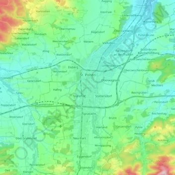
Name: St. Pölten topographic map, elevation, terrain.
Location: St. Pölten, Lower Austria, Austria (48.11848 15.55590 48.26830 15.73918)
Average elevation: 309 m
Minimum elevation: 227 m
Maximum elevation: 625 m
Make a donation
Gear up for your next adventure:
As an Amazon Associate, this site earns from qualifying purchases at no extra cost to you.
Other topographic maps
Click on a map to view its topography, its elevation and its terrain.
Suttenbrunn
Austria > Lower Austria > Bezirk Hollabrunn > Gemeinde Hollabrunn
Average elevation: 258 m
Klosterwappen
Austria > Lower Austria > Bezirk Neunkirchen > Reichenau an der Rax
Average elevation: 1,715 m
Make a donation
Gear up for your next adventure:
As an Amazon Associate, this site earns from qualifying purchases at no extra cost to you.
Kirchberg an der Pielach
Austria > Lower Austria > Bezirk St. Pölten > Gemeinde Kirchberg an der Pielach > Kirchberg an der Pielach
Average elevation: 480 m
Make a donation
Gear up for your next adventure:
As an Amazon Associate, this site earns from qualifying purchases at no extra cost to you.
Klein-Wien
Austria > Lower Austria > Bezirk Krems > Gemeinde Furth bei Göttweig
Average elevation: 308 m
Sois
Austria > Lower Austria > Bezirk St. Pölten > Gemeinde Kirchberg an der Pielach
Average elevation: 494 m
Plackles
Austria > Lower Austria > Bezirk Wiener Neustadt > Gemeinde Hohe Wand
Average elevation: 867 m
Make a donation
Gear up for your next adventure:
As an Amazon Associate, this site earns from qualifying purchases at no extra cost to you.