
Make a donation
Gear up for your next adventure:
As an Amazon Associate, this site earns from qualifying purchases at no extra cost to you.
Conger Lake topographic map
Click on the map to display elevation.
Make a donation
Gear up for your next adventure:
As an Amazon Associate, this site earns from qualifying purchases at no extra cost to you.
About this map
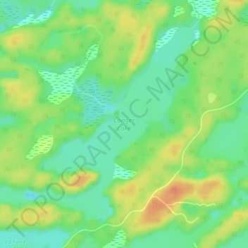
Name: Conger Lake topographic map, elevation, terrain.
Average elevation: 200 m
Minimum elevation: 182 m
Maximum elevation: 220 m
Make a donation
Gear up for your next adventure:
As an Amazon Associate, this site earns from qualifying purchases at no extra cost to you.
Other topographic maps
Click on a map to view its topography, its elevation and its terrain.
Moon River
Canada > Ontario > Parry Sound District > The Archipelago Township
Average elevation: 185 m
Pointe au Baril
Canada > Ontario > Parry Sound District > The Archipelago Township
Average elevation: 177 m
Moon River
Canada > Ontario > Parry Sound District > The Archipelago Township
Average elevation: 185 m
Deer Horn Island
Canada > Ontario > Parry Sound District > The Archipelago Township
Average elevation: 199 m
Make a donation
Gear up for your next adventure:
As an Amazon Associate, this site earns from qualifying purchases at no extra cost to you.
Watt Island
Canada > Ontario > Parry Sound District > The Archipelago Township
Average elevation: 195 m