
Baoding City topographic map
Interactive map
Click on the map to display elevation.
About this map
Name: Baoding City topographic map, elevation, terrain.
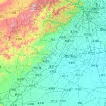
Location: Baoding City, Hebei, China (38.23222 113.75991 39.95121 116.24213)
Average elevation: 338 m
Minimum elevation: 2 m
Maximum elevation: 2,805 m
Elevations in Baoding's administrative area decrease from northwest to southeast. The western parts are dominated by mountains and hills that are generally more than 1,000 metres (3,300 ft) tall; this area includes parts of Laishui, Yi, Mancheng, Shunping, Tang and Fuping Counties as well as the entirety of Laiyuan County, occupying 30.6% of the prefecture's area. The highest peak is Mount Waitou (歪头山), with an elevation of 2,286 metres (7,500 ft). Moving southeast from this area, one encounters low-lying mountains and hills, taking up 18.9% of the prefecture's area. Further to the east lies generally flat terrain of 30 to 100 metres (98 to 330 ft) elevation. Here the primary rivers are the Xiaoyi River (孝义河), Fu River (府河), Bao River(瀑河), Ping River(萍河), Juma River(拒马河), Yishui River (易水河), Tang River (唐河), Cao River(漕河), Zhulong River(潴龙河), Qingshui River (清水河),and Sha River (沙河)s.Baiyangdian Lake, the largest natural lake in northern China, can be found nearby.
Other topographic maps
Click on a map to view its topography, its elevation and its terrain.