Geolocate

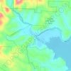
Lake James topographic map

Click on the map to display elevation.

Lake James

Lake James is a large reservoir in the mountains of Western North Carolina which straddles the border between Burke and McDowell Counties. It is named for tobacco tycoon and benefactor of Duke University James Buchanan Duke. The lake, with surface elevation of 1200 ft (366 m), lies behind a series of 3 earthen dams. It was created by Duke Power between 1916 and 1923 as a hydro-electric project. It still generates power today and is the uppermost lake on the Catawba River system.

Wikipedia (CC-BY-SA 3.0)

About this map

Name: Lake James topographic map, elevation, terrain.

Location: Lake James, Burke County, North Carolina, United States (35.71392 -81.99982 35.79624 -81.82004)

Average elevation: 381 m

Minimum elevation: 311 m

Maximum elevation: 849 m

Other topographic maps

Click on a map to view its topography, its elevation and its terrain.
Jonas Ridge

United States > North Carolina > Burke County

Average elevation: 1,136 m

Parkhill

United States > North Carolina > Burke County

Average elevation: 368 m

Jonas Ridge

United States > North Carolina > Burke County

Average elevation: 1,136 m

Linville

United States > North Carolina > Burke County

Average elevation: 412 m

Gold

United States > North Carolina > Burke County

Average elevation: 369 m

Jonas Ridge

United States > North Carolina > Burke County

Average elevation: 1,136 m

Gear up for your next adventure:

🩹First Aid Kits - Essential kits for outdoor safety
🧴Long-Lasting Sunscreen - Protect against UV rays during long days on the ridges
🔗Locking Carabiners - Secure gear to your pack or for light climbing
🛸Lightweight Camera Drones - Capture stunning aerial topographic views of the landscape
🚲Cycling GPS Computers - Topographic mapping for Irish road and mountain biking

As an Amazon Associate, this site earns from qualifying purchases at no extra cost to you.