
Make a donation
Gear up for your next adventure:
As an Amazon Associate, this site earns from qualifying purchases at no extra cost to you.
Buffalo River topographic map
Click on the map to display elevation.
Make a donation
Gear up for your next adventure:
As an Amazon Associate, this site earns from qualifying purchases at no extra cost to you.
Buffalo River
The Buffalo River has its source in the seeps and sponges of the Amatola Mountains at an altitude of 1200 m. The river is 126 kilometres long and drains a catchment of 1287 square kilometres. From its source, the river descends through indigenous forest in a deeply incised channel, flanked by rock cliffs up to 120 metres high. The quality of these headwaters is good. After only seven kilometres, the river faces its first obstruction, the small Maden Dam, built in 1910 (114 years old). Four kilometres downstream of Maden Dam, the much larger Rooikrantz Dam impounds about five million cubic metres. Rooikrantz Dam supplies water to King William's Town and the surrounding areas. Twenty kilometres from its source, at an altitude of 450 metres above mean sea level, the Cwengcwe River and Izele River join the Buffalo from the northeast. From here the river runs through undulating plains.
Make a donation
Gear up for your next adventure:
As an Amazon Associate, this site earns from qualifying purchases at no extra cost to you.
About this map
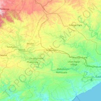
Name: Buffalo River topographic map, elevation, terrain.
Average elevation: 395 m
Minimum elevation: -1 m
Maximum elevation: 1,410 m
Make a donation
Gear up for your next adventure:
As an Amazon Associate, this site earns from qualifying purchases at no extra cost to you.
Other topographic maps
Click on a map to view its topography, its elevation and its terrain.
KuGompo City
South Africa > Eastern Cape > Buffalo City Metropolitan Municipality
Average elevation: 72 m
Mdantsane
South Africa > Eastern Cape > Buffalo City Metropolitan Municipality
Average elevation: 264 m
Make a donation
Gear up for your next adventure:
As an Amazon Associate, this site earns from qualifying purchases at no extra cost to you.
Bridle Drift Dam
South Africa > Eastern Cape > Buffalo City Metropolitan Municipality > Zwelitsha
Average elevation: 233 m
Zwelitsha
South Africa > Eastern Cape > Buffalo City Metropolitan Municipality
Average elevation: 397 m
Nahoon River Picnic Park
South Africa > Eastern Cape > Buffalo City Metropolitan Municipality > KuGompo City
Average elevation: 51 m
Make a donation
Gear up for your next adventure:
As an Amazon Associate, this site earns from qualifying purchases at no extra cost to you.
Christmas Rock
South Africa > Eastern Cape > Buffalo City Metropolitan Municipality
Average elevation: 26 m
Nahoon Dam
South Africa > Eastern Cape > Buffalo City Metropolitan Municipality
Average elevation: 177 m
Nohlazana
South Africa > Eastern Cape > Buffalo City Metropolitan Municipality
Average elevation: 247 m
Make a donation
Gear up for your next adventure:
As an Amazon Associate, this site earns from qualifying purchases at no extra cost to you.
King Williams Town Nature Reserve
South Africa > Eastern Cape > Buffalo City Metropolitan Municipality > Qonce
Average elevation: 482 m
Kayser's Beach
South Africa > Eastern Cape > Buffalo City Metropolitan Municipality
Average elevation: 28 m
KuGompo City
South Africa > Eastern Cape > Buffalo City Metropolitan Municipality
Average elevation: 72 m
Nahoon River
South Africa > Eastern Cape > Buffalo City Metropolitan Municipality > KuGompo City
Average elevation: 65 m
Make a donation
Gear up for your next adventure:
As an Amazon Associate, this site earns from qualifying purchases at no extra cost to you.
KuGompo City
South Africa > Eastern Cape > Buffalo City Metropolitan Municipality
Average elevation: 72 m
KuGompo City
South Africa > Eastern Cape > Buffalo City Metropolitan Municipality
Average elevation: 72 m
KuGompo City
South Africa > Eastern Cape > Buffalo City Metropolitan Municipality
Average elevation: 72 m
Make a donation
Gear up for your next adventure:
As an Amazon Associate, this site earns from qualifying purchases at no extra cost to you.
Breidbach
South Africa > Eastern Cape > Buffalo City Metropolitan Municipality
Average elevation: 424 m
Ekuphumleni
South Africa > Eastern Cape > Buffalo City Metropolitan Municipality
Average elevation: 383 m
Mdantsane
South Africa > Eastern Cape > Buffalo City Metropolitan Municipality
Average elevation: 264 m
Make a donation
Gear up for your next adventure:
As an Amazon Associate, this site earns from qualifying purchases at no extra cost to you.
Mdantsane
South Africa > Eastern Cape > Buffalo City Metropolitan Municipality
Average elevation: 264 m
Nohlazana
South Africa > Eastern Cape > Buffalo City Metropolitan Municipality
Average elevation: 247 m
East London
South Africa > Eastern Cape > Buffalo City Metropolitan Municipality
Average elevation: 72 m
East London
South Africa > Eastern Cape > Buffalo City Metropolitan Municipality
Average elevation: 72 m
Make a donation
Gear up for your next adventure:
As an Amazon Associate, this site earns from qualifying purchases at no extra cost to you.
Phakamisa
South Africa > Eastern Cape > Buffalo City Metropolitan Municipality
Average elevation: 379 m
East London
South Africa > Eastern Cape > Buffalo City Metropolitan Municipality
Average elevation: 72 m