
Make a donation
Gear up for your next adventure:
As an Amazon Associate, this site earns from qualifying purchases at no extra cost to you.
Great Mills topographic map
Click on the map to display elevation.
Make a donation
Gear up for your next adventure:
As an Amazon Associate, this site earns from qualifying purchases at no extra cost to you.
About this map
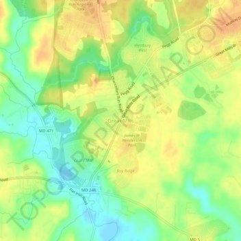
Name: Great Mills topographic map, elevation, terrain.
Average elevation: 22 m
Minimum elevation: 2 m
Maximum elevation: 37 m
Make a donation
Gear up for your next adventure:
As an Amazon Associate, this site earns from qualifying purchases at no extra cost to you.
Other topographic maps
Click on a map to view its topography, its elevation and its terrain.
Mechanicsville
United States > Maryland > Saint Mary's County > Mechanicsville
Average elevation: 46 m
St. George Island
United States > Maryland > Saint Mary's County > Piney Point > Saint George Island
Average elevation: 0 m
Make a donation
Gear up for your next adventure:
As an Amazon Associate, this site earns from qualifying purchases at no extra cost to you.
Charlotte Hall
United States > Maryland > Saint Mary's County > Charlotte Hall
Average elevation: 49 m
Lexington Park
United States > Maryland > Saint Mary's County > Lexington Park
Average elevation: 24 m
Lexington Park
United States > Maryland > Saint Mary's County > Lexington Park
Average elevation: 24 m
Make a donation
Gear up for your next adventure:
As an Amazon Associate, this site earns from qualifying purchases at no extra cost to you.
Mechanicsville
United States > Maryland > Saint Mary's County > Mechanicsville
Average elevation: 46 m
Lexington Park
United States > Maryland > Saint Mary's County > Lexington Park
Average elevation: 24 m
Make a donation
Gear up for your next adventure:
As an Amazon Associate, this site earns from qualifying purchases at no extra cost to you.