
Make a donation
Gear up for your next adventure:
As an Amazon Associate, this site earns from qualifying purchases at no extra cost to you.
Center Valley topographic map
Click on the map to display elevation.
Make a donation
Gear up for your next adventure:
As an Amazon Associate, this site earns from qualifying purchases at no extra cost to you.
About this map
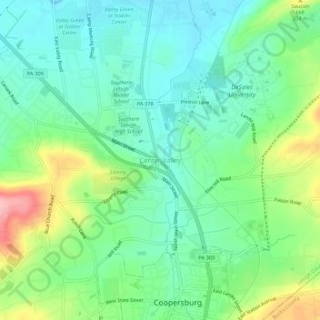
Name: Center Valley topographic map, elevation, terrain.
Average elevation: 152 m
Minimum elevation: 108 m
Maximum elevation: 252 m
Make a donation
Gear up for your next adventure:
As an Amazon Associate, this site earns from qualifying purchases at no extra cost to you.
Other topographic maps
Click on a map to view its topography, its elevation and its terrain.
Upper Saucon
United States > Pennsylvania > Lehigh County > Upper Saucon
According to the United States Census Bureau, the township has a total area of 24.6 square miles (63.7 km2), of which 24.5 square miles (63.4 km2) are land and 0.2 square miles (0.4 km2), or 0.59%, are water. Its boundary with Salisbury Township is located on South Mountain. Elevations range from 340 feet (100…
Average elevation: 175 m