
Make a donation
Gear up for your next adventure:
As an Amazon Associate, this site earns from qualifying purchases at no extra cost to you.
Konradsburg topographic map
Click on the map to display elevation.
Make a donation
Gear up for your next adventure:
As an Amazon Associate, this site earns from qualifying purchases at no extra cost to you.
Konradsburg
Die Höhenburg liegt direkt nordöstlich des Mittelgebirges Harz im Naturpark Harz/Sachsen-Anhalt. Sie befindet sich etwa sechs Kilometer westlich von Aschersleben und etwa zwei Kilometer südlich vom Falkensteiner Ortsteil Ermsleben auf dem 236,2 m ü. NHN hohen Burgberg. Südlich unterhalb der Burg liegt am kleinen Bach Liethe die Ansiedlung Burggrund mit einem auf 198,3 m gelegenen Teich.
Make a donation
Gear up for your next adventure:
As an Amazon Associate, this site earns from qualifying purchases at no extra cost to you.
About this map
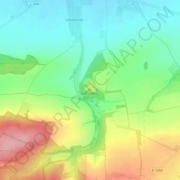
Name: Konradsburg topographic map, elevation, terrain.
Average elevation: 218 m
Minimum elevation: 163 m
Maximum elevation: 303 m
Make a donation
Gear up for your next adventure:
As an Amazon Associate, this site earns from qualifying purchases at no extra cost to you.
Other topographic maps
Click on a map to view its topography, its elevation and its terrain.