
Thank you for supporting this site ❤️
Make a donation
Make a donation
Gear up for your next adventure:
As an Amazon Associate, this site earns from qualifying purchases at no extra cost to you.
Bad Vöslau topographic map
Click on the map to display elevation.
Thank you for supporting this site ❤️
Make a donation
Make a donation
Gear up for your next adventure:
As an Amazon Associate, this site earns from qualifying purchases at no extra cost to you.
About this map
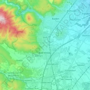
Name: Bad Vöslau topographic map, elevation, terrain.
Location: Bad Vöslau, Bezirk Baden, Lower Austria, Austria (47.94335 16.08584 48.00650 16.25249)
Average elevation: 313 m
Minimum elevation: 194 m
Maximum elevation: 831 m
Thank you for supporting this site ❤️
Make a donation
Make a donation
Gear up for your next adventure:
As an Amazon Associate, this site earns from qualifying purchases at no extra cost to you.
Other topographic maps
Click on a map to view its topography, its elevation and its terrain.
Matterhorn
Austria > Lower Austria > Bezirk Baden > Altenmarkt an der Triesting
Average elevation: 526 m