
Thank you for supporting this site ❤️
Make a donation
Make a donation
Gear up for your next adventure:
As an Amazon Associate, this site earns from qualifying purchases at no extra cost to you.
Bugonje topographic map
Click on the map to display elevation.
Thank you for supporting this site ❤️
Make a donation
Make a donation
Gear up for your next adventure:
As an Amazon Associate, this site earns from qualifying purchases at no extra cost to you.
About this map
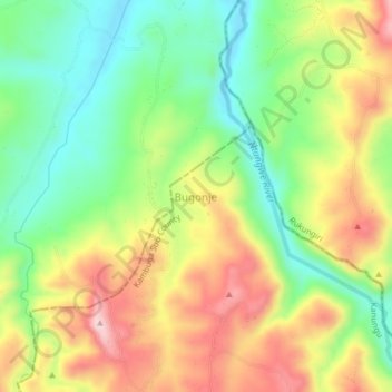
Name: Bugonje topographic map, elevation, terrain.
Location: Bugonje, Kambuga Sub-County, Kanungu, Western Region, Uganda (-0.75333 29.78000 -0.71333 29.82000)
Average elevation: 1,182 m
Minimum elevation: 1,049 m
Maximum elevation: 1,353 m
Thank you for supporting this site ❤️
Make a donation
Make a donation
Gear up for your next adventure:
As an Amazon Associate, this site earns from qualifying purchases at no extra cost to you.