
Make a donation
Gear up for your next adventure:
As an Amazon Associate, this site earns from qualifying purchases at no extra cost to you.
Princes Lake topographic map
Click on the map to display elevation.
Make a donation
Gear up for your next adventure:
As an Amazon Associate, this site earns from qualifying purchases at no extra cost to you.
About this map
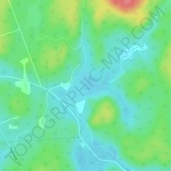
Name: Princes Lake topographic map, elevation, terrain.
Average elevation: 467 m
Minimum elevation: 445 m
Maximum elevation: 522 m
Make a donation
Gear up for your next adventure:
As an Amazon Associate, this site earns from qualifying purchases at no extra cost to you.
Other topographic maps
Click on a map to view its topography, its elevation and its terrain.
Victoria Lake
Canada > Ontario > Nipissing District > South Algonquin Township
Average elevation: 407 m
Make a donation
Gear up for your next adventure:
As an Amazon Associate, this site earns from qualifying purchases at no extra cost to you.
Bellwood
Canada > Ontario > Nipissing District > South Algonquin Township > Whitney
Average elevation: 410 m
Madawaska Highlands
Canada > Ontario > Nipissing District > South Algonquin Township
Average elevation: 442 m
Make a donation
Gear up for your next adventure:
As an Amazon Associate, this site earns from qualifying purchases at no extra cost to you.