Geolocate

Highland topographic map

Click on the map to display elevation.

About this map

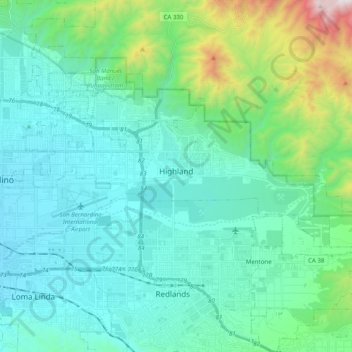
Name: Highland topographic map, elevation, terrain.

Location: Highland, San Bernardino County, California, United States (34.07691 -117.26106 34.14274 -117.06336)

Average elevation: 601 m

Minimum elevation: 303 m

Maximum elevation: 1,994 m

Other topographic maps

Click on a map to view its topography, its elevation and its terrain.

Earp

United States > California > San Bernardino County

Average elevation: 137 m

Oak Glen

United States > California > San Bernardino County

Average elevation: 1,610 m

Gear up for your next adventure:

🪵Fire Starters & Tools - Tools to start fire in wet conditions
🌿Irish Flora Guides - Identify plants while exploring the countryside
🧯Portable Extinguishers - Safety tools for campfires
🥾Lightweight Hiking Shoes - Light, breathable shoes for trail walking
📊Altimeters & Barometers - Track elevation and weather changes

As an Amazon Associate, this site earns from qualifying purchases at no extra cost to you.