
Make a donation
Gear up for your next adventure:
As an Amazon Associate, this site earns from qualifying purchases at no extra cost to you.
Heide topographic map
Click on the map to display elevation.
Make a donation
Gear up for your next adventure:
As an Amazon Associate, this site earns from qualifying purchases at no extra cost to you.
About this map
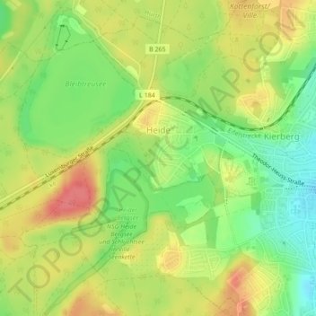
Name: Heide topographic map, elevation, terrain.
Location: Heide, Brühl, Rhein-Erft-Kreis, Nordrhein-Westfalen, Deutschland (50.82763 6.86533 50.83952 6.88371)
Average elevation: 105 m
Minimum elevation: 72 m
Maximum elevation: 136 m
Make a donation
Gear up for your next adventure:
As an Amazon Associate, this site earns from qualifying purchases at no extra cost to you.
Other topographic maps
Click on a map to view its topography, its elevation and its terrain.
Geildorf
Deutschland > Nordrhein-Westfalen > Rhein-Erft-Kreis > Brühl > Geildorf
Average elevation: 92 m
Make a donation
Gear up for your next adventure:
As an Amazon Associate, this site earns from qualifying purchases at no extra cost to you.