
Make a donation
Gear up for your next adventure:
As an Amazon Associate, this site earns from qualifying purchases at no extra cost to you.
Howell topographic map
Click on the map to display elevation.
Make a donation
Gear up for your next adventure:
As an Amazon Associate, this site earns from qualifying purchases at no extra cost to you.
About this map
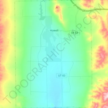
Name: Howell topographic map, elevation, terrain.
Location: Howell, Box Elder County, Utah, 84316, United States (41.72186 -112.49488 41.82488 -112.39493)
Average elevation: 1,460 m
Minimum elevation: 1,354 m
Maximum elevation: 1,746 m
Make a donation
Gear up for your next adventure:
As an Amazon Associate, this site earns from qualifying purchases at no extra cost to you.
Other topographic maps
Click on a map to view its topography, its elevation and its terrain.
Grouse Creek
United States > Utah > Box Elder County
Grouse Creek (also Cookesville) is an unincorporated community in the nearly unpopulated northwestern region of Box Elder County, Utah, United States, near the Idaho and Nevada borders. The community lies along unpaved roads north of State Route 30 in the Grouse Creek Mountains. Its elevation is 5,331 feet…
Average elevation: 1,653 m
Brigham City
United States > Utah > Box Elder County > Brigham City > Brigham City
Average elevation: 1,489 m