
Thank you for supporting this site ❤️
Make a donation
Make a donation
Gear up for your next adventure:
As an Amazon Associate, this site earns from qualifying purchases at no extra cost to you.
Mencoriari topographic map
Click on the map to display elevation.
Thank you for supporting this site ❤️
Make a donation
Make a donation
Gear up for your next adventure:
As an Amazon Associate, this site earns from qualifying purchases at no extra cost to you.
About this map
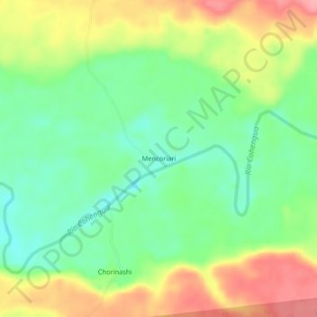
Name: Mencoriari topographic map, elevation, terrain.
Location: Mencoriari, Raymondi, Atalaya, Ucayali, Perú (-10.34606 -73.78645 -10.30606 -73.74645)
Average elevation: 255 m
Minimum elevation: 211 m
Maximum elevation: 315 m
Thank you for supporting this site ❤️
Make a donation
Make a donation
Gear up for your next adventure:
As an Amazon Associate, this site earns from qualifying purchases at no extra cost to you.