
Make a donation
Gear up for your next adventure:
As an Amazon Associate, this site earns from qualifying purchases at no extra cost to you.
Florence topographic map
Click on the map to display elevation.
Make a donation
Gear up for your next adventure:
As an Amazon Associate, this site earns from qualifying purchases at no extra cost to you.
Florence
Florence is located in the coastal plain of South Carolina. It is in the northeastern part of the state and the northern part of Florence County. The average elevation above sea level is around 140 ft (43 m). Jeffries Creek is a tributary of the Great Pee Dee River and is the main waterway that flows through the city, passing south of the city center. According to the United States Census Bureau, the city has a total area of 23.49 square miles (60.8 km2), of which 23.39 square miles (60.6 km2) is land and 0.09 square miles (0.23 km2) (0.38%) is water.
Make a donation
Gear up for your next adventure:
As an Amazon Associate, this site earns from qualifying purchases at no extra cost to you.
About this map
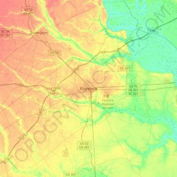
Name: Florence topographic map, elevation, terrain.
Average elevation: 35 m
Minimum elevation: 9 m
Maximum elevation: 62 m
Make a donation
Gear up for your next adventure:
As an Amazon Associate, this site earns from qualifying purchases at no extra cost to you.
Other topographic maps
Click on a map to view its topography, its elevation and its terrain.
Florence
United States > South Carolina > Florence County
Florence is located in the coastal plain of South Carolina. It is in the northeastern part of the state and the northern part of Florence County. The average elevation above sea level is around 140 ft (43 m). Jeffries Creek is a tributary of the Great Pee Dee River and is the main waterway that flows through…
Average elevation: 37 m
Florence Soccer Complex
United States > South Carolina > Florence County > Florence
Average elevation: 42 m
Make a donation
Gear up for your next adventure:
As an Amazon Associate, this site earns from qualifying purchases at no extra cost to you.
Florence
United States > South Carolina > Florence County
Florence is located in the coastal plain of South Carolina. It is in the northeastern part of the state and the northern part of Florence County. The average elevation above sea level is around 140 ft (43 m). Jeffries Creek is a tributary of the Great Pee Dee River and is the main waterway that flows through…
Average elevation: 37 m