
Telomoyo topographic map
Interactive map
Click on the map to display elevation.
About this map
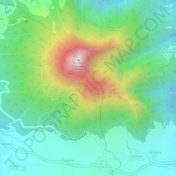
Name: Telomoyo topographic map, elevation, terrain.
Location: Telomoyo, Magelang, Zentral-Java, 56194, Indonesien (-7.36554 110.40146 -7.36544 110.40156)
Average elevation: 1,386 m
Minimum elevation: 1,152 m
Maximum elevation: 1,869 m
Other topographic maps
Click on a map to view its topography, its elevation and its terrain.
Telaga
Indonesien > Zentral-Java > Brebes
Telaga, Brebes, Zentral-Java, Indonesien
Average elevation: 321 m
Gunung Sindoro
Gunung Sindoro, Wonosobo, Zentral-Java, Indonesien
Average elevation: 2,572 m
Magelang
Indonesien > Zentral-Java > Magelang
Magelang, Zentral-Java, 56126, Indonesien
Average elevation: 635 m
Puncak Trianggulasi
Indonesien > Zentral-Java > Jrakah
Puncak Trianggulasi, Jrakah, Zentral-Java, Indonesien
Average elevation: 2,696 m