
City of Freeport topographic map
Interactive map
Click on the map to display elevation.
About this map
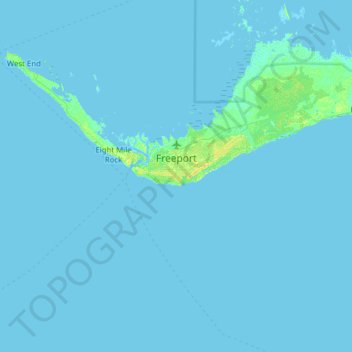
Name: City of Freeport topographic map, elevation, terrain.
Location: City of Freeport, Bahamas (26.28900 -78.92669 26.72319 -78.30552)
Average elevation: 1 m
Minimum elevation: -1 m
Maximum elevation: 14 m
Other topographic maps
Click on a map to view its topography, its elevation and its terrain.
Great Stirrup Cay
Great Stirrup Cay, Berry Islands, Bahamas
Average elevation: 1 m
Skyline Heights
Skyline Heights, New Providence, Bahamas
Average elevation: 9 m
Marsh Harbour
Bahamas > Marsh Harbour > Marsh Harbour
Marsh Harbour, AB20087, Bahamas
Average elevation: 2 m