Geolocate

Riverside topographic map

Click on the map to display elevation.

About this map

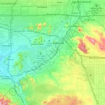
Name: Riverside topographic map, elevation, terrain.

Location: Riverside, Riverside County, California, 92506, United States (33.79335 -117.55616 34.11335 -117.23616)

Average elevation: 372 m

Minimum elevation: 163 m

Maximum elevation: 1,050 m

Other topographic maps

Click on a map to view its topography, its elevation and its terrain.

Gear up for your next adventure:

⛷️Mountain Sports Accessories - Gear for high intensity outdoor sports
🍖Freeze-Dried Trail Meals - Nutritious and lightweight food for expeditions
Emergency Bivvy Bags - Life-saving heat-reflective shelter for emergencies
📟Handheld Altimeters - Track elevation changes and weather patterns accurately
🌧️Rain Gear for Hiking - Waterproof gear sets for wet hikes

As an Amazon Associate, this site earns from qualifying purchases at no extra cost to you.