
Make a donation
Gear up for your next adventure:
As an Amazon Associate, this site earns from qualifying purchases at no extra cost to you.
Le Villard topographic map
Click on the map to display elevation.
Make a donation
Gear up for your next adventure:
As an Amazon Associate, this site earns from qualifying purchases at no extra cost to you.
About this map
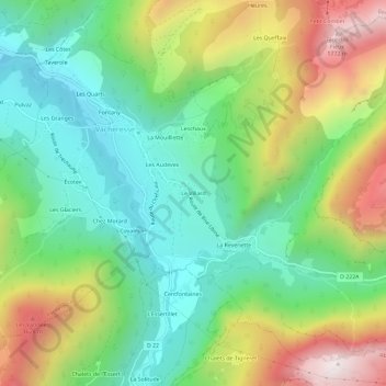
Name: Le Villard topographic map, elevation, terrain.
Average elevation: 1,131 m
Minimum elevation: 741 m
Maximum elevation: 1,813 m
Make a donation
Gear up for your next adventure:
As an Amazon Associate, this site earns from qualifying purchases at no extra cost to you.
Other topographic maps
Click on a map to view its topography, its elevation and its terrain.
Lac de Darbon
France > Auvergne-Rhône-Alpes > Haute-Savoie > Vacheresse
C'est un petit lac de montagne, d'une surface de deux hectares environ, situé à 1 813 mètres d'altitude, au sud-est des sommets de la Dent d'Oche et du Château d'Oche.
Average elevation: 1,781 m