
Make a donation
Gear up for your next adventure:
As an Amazon Associate, this site earns from qualifying purchases at no extra cost to you.
Notschrei topographic map
Click on the map to display elevation.
Make a donation
Gear up for your next adventure:
As an Amazon Associate, this site earns from qualifying purchases at no extra cost to you.
Notschrei
Die Passhöhe mit 1120,1 m ü. NHN liegt fünf Kilometer westlich des Feldbergs in der Gemarkung Todtnau und ist nach der Hohtannhöhe der zweithöchste Pass im Landkreis Lörrach. Vor dem Nordanstieg der Landesstraße 126 südlich von Oberried führt eine Stichstraße nach Osten in das zu Oberried gehörende St. Wilhelmer Tal; auf halber Höhe zweigt beim Steinwasen-Park die Kreisstraße 4996 nach Hofsgrund und zur Landesstraße 124 auf der Halde beim Schauinsland ab. Auf der Südseite liegen zwischen der Passhöhe und Todtnau die Ortschaften Muggenbrunn und Aftersteg, zwischen denen eine Stichstraße zum östlich gelegenen Gemeindeteil Todtnauberg führt.
Make a donation
Gear up for your next adventure:
As an Amazon Associate, this site earns from qualifying purchases at no extra cost to you.
About this map
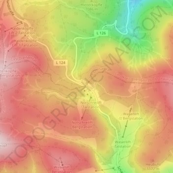
Name: Notschrei topographic map, elevation, terrain.
Average elevation: 1,131 m
Minimum elevation: 889 m
Maximum elevation: 1,274 m
Make a donation
Gear up for your next adventure:
As an Amazon Associate, this site earns from qualifying purchases at no extra cost to you.
Other topographic maps
Click on a map to view its topography, its elevation and its terrain.
Todtnauberg
Deutschland > Baden-Württemberg > Landkreis Lörrach > Todtnau
Der Todtnauberger Wasserfall ist mit 97 Metern Fallhöhe in fünf Fallstufen einer der höchsten Wasserfälle Deutschlands.
Average elevation: 1,117 m