
Make a donation
Gear up for your next adventure:
As an Amazon Associate, this site earns from qualifying purchases at no extra cost to you.
Gries topographic map
Click on the map to display elevation.
Make a donation
Gear up for your next adventure:
As an Amazon Associate, this site earns from qualifying purchases at no extra cost to you.
Gries
L'altitude minimum de Gries est de 125 m et son altitude maximum est de 169 m, soit un relief relativement plat. Gries est entourée de cultures diverses (maïs...).
Make a donation
Gear up for your next adventure:
As an Amazon Associate, this site earns from qualifying purchases at no extra cost to you.
About this map
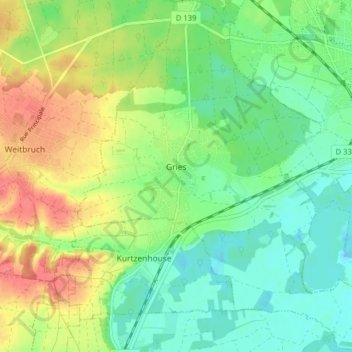
Name: Gries topographic map, elevation, terrain.
Average elevation: 145 m
Minimum elevation: 121 m
Maximum elevation: 182 m
Make a donation
Gear up for your next adventure:
As an Amazon Associate, this site earns from qualifying purchases at no extra cost to you.
Other topographic maps
Click on a map to view its topography, its elevation and its terrain.
Ecluse de Markolsheim
France > Grand Est > Bas-Rhin > Marckolsheim > Hameau du Rhin
Average elevation: 180 m