
Make a donation
Gear up for your next adventure:
As an Amazon Associate, this site earns from qualifying purchases at no extra cost to you.
Montpelier topographic map
Click on the map to display elevation.
Make a donation
Gear up for your next adventure:
As an Amazon Associate, this site earns from qualifying purchases at no extra cost to you.
Montpelier
Montpelier is located in the north-central area of Vermont. The city center is a flat clay zone (elevation 520 ft; 160 m), surrounded by hills and granite ledges. Towne Hill runs in a 2-mile (3.2 km) ridge (~900 ft; 270 m) along the northern edge of the city.
Make a donation
Gear up for your next adventure:
As an Amazon Associate, this site earns from qualifying purchases at no extra cost to you.
About this map
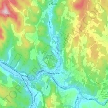
Name: Montpelier topographic map, elevation, terrain.
Location: Montpelier, Washington County, Vermont, 05602, United States (44.23492 -72.61245 44.31331 -72.52509)
Average elevation: 284 m
Minimum elevation: 152 m
Maximum elevation: 564 m
Make a donation
Gear up for your next adventure:
As an Amazon Associate, this site earns from qualifying purchases at no extra cost to you.