
Senftenbach topographic map
Interactive map
Click on the map to display elevation.
About this map
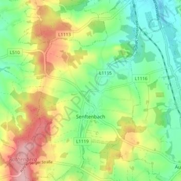
Name: Senftenbach topographic map, elevation, terrain.
Location: Senftenbach, Bezirk Ried im Innkreis, 4973, Österreich (48.24453 13.39153 48.29037 13.43585)
Average elevation: 432 m
Minimum elevation: 369 m
Maximum elevation: 529 m
Senftenbach liegt auf 414 m Höhe im Innviertel. Die Ausdehnung beträgt von Nord nach Süd 5 km, von West nach Ost 3,3 km. Die Gesamtfläche beträgt 9,8 km². 19,4 % der Fläche sind bewaldet, 73,5 % der Fläche sind landwirtschaftlich genutzt.
Other topographic maps
Click on a map to view its topography, its elevation and its terrain.
Pattigham
Österreich > Bezirk Ried im Innkreis
Pattigham, Bezirk Ried im Innkreis, 4910, Österreich
Average elevation: 521 m