
Ballarat topographic map
Interactive map
Click on the map to display elevation.
About this map
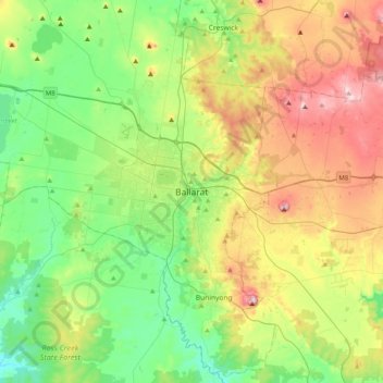
Name: Ballarat topographic map, elevation, terrain.
Location: Ballarat, City of Ballarat, Victoria, 3350, Australie (-37.72230 143.70056 -37.40230 144.02056)
Average elevation: 470 m
Minimum elevation: 325 m
Maximum elevation: 740 m
Ballarat (/ˈbæ.lə.ˌɹæt/) est une importante ville continentale de l'État de Victoria, en Australie. Avec 98 888 habitants, c'est, par sa population, la troisième ville de l'État, derrière Melbourne et Geelong, la troisième ville continentale de toute l'Australie derrière Canberra, la capitale fédérale et Toowoomba, dans le Queensland. Elle est située à environ 120 km au nord-ouest de Melbourne. Située à 441 m d'altitude, elle occupe une superficie administrative d'environ 740 km2, une surface bâtie d'environ 75 km2.
Other topographic maps
Click on a map to view its topography, its elevation and its terrain.
Wilsons Promontory
Wilsons Promontory, Shire of South Gippsland, Victoria, 3960, Australie
Average elevation: 38 m
Melbourne Water Pipe Reserve
Australie > Victoria > Melbourne
Melbourne Water Pipe Reserve, Nunawading, Melbourne, City of Whitehorse, Victoria, Australie
Average elevation: 133 m
Melbourne-Sud
Australie > Victoria > Melbourne
Melbourne-Sud, Melbourne, City of Port Phillip, Victoria, 3205, Australie
Average elevation: 9 m
Mount Napier
Mount Napier, Shire of Southern Grampians, Victoria, Australie
Average elevation: 213 m
Burwood District
Australie > Victoria > Melbourne > Burwood
Burwood District, Burwood, Melbourne, City of Whitehorse, Victoria, 3125, Australie
Average elevation: 73 m
Melbourne District
Australie > Victoria > Melbourne
Melbourne District, Melbourne, City of Melbourne, Victoria, Australie
Average elevation: 20 m
Shire of South Gippsland
Shire of South Gippsland, Victoria, Australie
Average elevation: 81 m
Bacchus Marsh
Australie > Victoria > Bacchus Marsh
Bacchus Marsh, Shire of Moorabool, Victoria, 3340, Australie
Average elevation: 133 m
Shire of Yarra Ranges
Shire of Yarra Ranges, Victoria, Australie
Average elevation: 440 m
St Andrews Beach
St Andrews Beach, Shire of Mornington Peninsula, Victoria, Australie
Average elevation: 10 m
Tidal River
Tidal River, Shire of South Gippsland, Victoria, Australie
Average elevation: 146 m
Shire of Mornington Peninsula
Shire of Mornington Peninsula, Victoria, Australie
Average elevation: 23 m
Falls Creek
Australie > Victoria > Falls Creek Alpine Resort
Falls Creek, Falls Creek Alpine Resort, Victoria, 3699, Australie
Average elevation: 1,459 m
Mornington
Australie > Victoria > Mornington
Mornington, Shire of Mornington Peninsula, Victoria, 3931, Australie
Average elevation: 44 m
Grampians NP
Grampians NP, Glenelg River Road, Halls Gap, Shire of Southern Grampians, Grampians, Victoria, Australie
Average elevation: 262 m
City of Boroondara
City of Boroondara, Victoria, Australie
Average elevation: 53 m
Triplet Falls
Triplet Falls, Shire of Colac Otway, Barwon South West, Victoria, Australie
Average elevation: 366 m
Cook Creek
Cook Creek, Shire of Hepburn, Grampians, Victoria, Australie
Average elevation: 339 m
Great Otway National Park
Australie > Victoria > Forrest
Great Otway National Park, Kaanglang Road, Forrest, Shire of Colac Otway, Barwon South West, Victoria, 3236, Australie
Average elevation: 111 m
Nigretta Falls
Nigretta Falls, Shire of Southern Grampians, Barwon South West, Victoria, Australie
Average elevation: 171 m
Cape Schanck
Cape Schanck, Shire of Mornington Peninsula, Victoria, Australie
Average elevation: 83 m
Mornington District
Australie > Victoria > Melbourne
Mornington District, Melbourne, Shire of Mornington Peninsula, Victoria, Australie
Average elevation: 50 m
Shire of Corangamite
Shire of Corangamite, Victoria, Australie
Average elevation: 151 m
Mount Sunday
Mount Sunday, Shire of Mansfield, Hume, Victoria, Australie
Average elevation: 1,141 m
Pentland Hills
Australie > Victoria > Pentland Hills
Pentland Hills, Shire of Moorabool, Grampians, Victoria, 3341, Australie
Average elevation: 293 m
Mount Dandenong
Australie > Victoria > Montrose
Mount Dandenong, Montrose, Shire of Yarra Ranges, Victoria, 3765, Australie
Average elevation: 429 m