
Make a donation
Gear up for your next adventure:
As an Amazon Associate, this site earns from qualifying purchases at no extra cost to you.
Swain County topographic map
Click on the map to display elevation.
Make a donation
Gear up for your next adventure:
As an Amazon Associate, this site earns from qualifying purchases at no extra cost to you.
Swain County
According to the U.S. Census Bureau, Swain county has a total area of 541 square miles (1,400 km2), of which 528 square miles (1,370 km2) is land and 13 square miles (34 km2) (2.3%) is water. The county is located in the far western part of North Carolina in the Great Smoky Mountains and contains a larger proportion of the Great Smoky Mountains National Park than any other county in North Carolina or Tennessee. The highest point in the county is Clingmans Dome, elevation 6,643 feet, located on the NC/TN border. Clingman's is the third highest peak in North Carolina, and a walkable observation tower is located on its summit. The highest mountain in North Carolina and in the United States east of the Mississippi River is Mt. Mitchell, 6,684 feet, located northeast of Asheville.
Make a donation
Gear up for your next adventure:
As an Amazon Associate, this site earns from qualifying purchases at no extra cost to you.
About this map
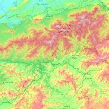
Name: Swain County topographic map, elevation, terrain.
Location: Swain County, North Carolina, United States (35.27911 -83.95339 35.69589 -83.15583)
Average elevation: 893 m
Minimum elevation: 267 m
Maximum elevation: 2,014 m
Make a donation
Gear up for your next adventure:
As an Amazon Associate, this site earns from qualifying purchases at no extra cost to you.