
Dromore topographic map
Interactive map
Click on the map to display elevation.
About this map
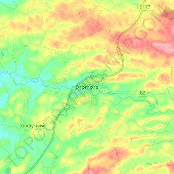
Name: Dromore topographic map, elevation, terrain.
Average elevation: 106 m
Minimum elevation: 56 m
Maximum elevation: 172 m
Other topographic maps
Click on a map to view its topography, its elevation and its terrain.
Slieve Donard
United Kingdom > Northern Ireland > County Down
Slieve Donard, County Down, Northern Ireland, BT33 0HD, United Kingdom
Average elevation: 505 m
Mourne Mountains Middle
United Kingdom > Northern Ireland > County Down
Mourne Mountains Middle, County Down, Northern Ireland, United Kingdom
Average elevation: 348 m
Banbridge
United Kingdom > Northern Ireland > County Down
Banbridge, County Down, Northern Ireland, BT32 3DB, United Kingdom
Average elevation: 90 m
Newry
United Kingdom > Northern Ireland > County Down
Newry, County Down, Northern Ireland, United Kingdom
Average elevation: 73 m
Drumaness
United Kingdom > Northern Ireland > County Down > Drumaness
Drumaness, County Down, Northern Ireland, BT24 8RL, United Kingdom
Average elevation: 74 m
Donaghadee
United Kingdom > Northern Ireland > County Down > Donaghadee
Donaghadee, County Down, Northern Ireland, BT21 0BD, United Kingdom
Average elevation: 10 m
Greencastle
United Kingdom > Northern Ireland > County Down > Greencastle
Greencastle, Greencastle Pier Road, Greencastle, County Down, Northern Ireland, BT34 4LR, United Kingdom
Average elevation: 1 m
Killyleagh
United Kingdom > Northern Ireland > County Down > Killyleagh
Killyleagh, County Down, Northern Ireland, BT30 9QF, United Kingdom
Average elevation: 11 m
Clonallan
United Kingdom > Northern Ireland > County Down > Mayobridge
Clonallan, Mayobridge, County Down, Northern Ireland, United Kingdom
Average elevation: 135 m
Ballymagart
United Kingdom > Northern Ireland > County Down
Ballymagart, County Down, Northern Ireland, United Kingdom
Average elevation: 33 m
Rathfriland
United Kingdom > Northern Ireland > County Down
Rathfriland, County Down, Northern Ireland, BT34 5NH, United Kingdom
Average elevation: 97 m
Ardglass
United Kingdom > Northern Ireland > County Down > Ardglass
Ardglass, County Down, Northern Ireland, BT30 7TU, United Kingdom
Average elevation: 7 m
Ballyquinton Point nature reserve
United Kingdom > Northern Ireland > County Down
Ballyquinton Point nature reserve, County Down, Northern Ireland, United Kingdom
Average elevation: 2 m
Kilkeel
United Kingdom > Northern Ireland > County Down > Kilkeel
Kilkeel, County Down, Northern Ireland, BT34 4AF, United Kingdom
Average elevation: 35 m
Dundrum
United Kingdom > Northern Ireland > County Down > Dundrum
Dundrum, County Down, Northern Ireland, BT33 0LU, United Kingdom
Average elevation: 18 m
Ballyhalbert
United Kingdom > Northern Ireland > County Down > Ballyhalbert
Ballyhalbert, County Down, Northern Ireland, BT22 1DQ, United Kingdom
Average elevation: 8 m
Knockchree
United Kingdom > Northern Ireland > County Down
Knockchree, County Down, Northern Ireland, BT34 4HT, United Kingdom
Average elevation: 116 m
Drumbo
United Kingdom > Northern Ireland > County Down > Drumbo
Drumbo, County Down, Northern Ireland, BT27 5TX, United Kingdom
Average elevation: 94 m
Mahee Island
United Kingdom > Northern Ireland > County Down
Mahee Island, County Down, Northern Ireland, United Kingdom
Average elevation: 2 m
Maghera
United Kingdom > Northern Ireland > County Down
Maghera, County Down, Northern Ireland, BT31 9HE, United Kingdom
Average elevation: 30 m
Newcastle
United Kingdom > Northern Ireland > County Down > Newcastle
Newcastle, County Down, Northern Ireland, BT33 0AE, United Kingdom
Average elevation: 115 m
Edenderry
United Kingdom > Northern Ireland > County Down
Edenderry, County Down, Ulster, Northern Ireland, BT8 8LQ, United Kingdom
Average elevation: 39 m