
Make a donation
Gear up for your next adventure:
As an Amazon Associate, this site earns from qualifying purchases at no extra cost to you.
Makilala topographic map
Click on the map to display elevation.
Make a donation
Gear up for your next adventure:
As an Amazon Associate, this site earns from qualifying purchases at no extra cost to you.
About this map
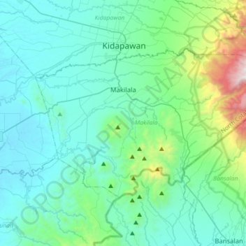
Name: Makilala topographic map, elevation, terrain.
Location: Makilala, North Cotabato, Soccsksargen, 9401, Philippines (6.83948 124.98917 7.00610 125.27078)
Average elevation: 380 m
Minimum elevation: 39 m
Maximum elevation: 2,267 m
Make a donation
Gear up for your next adventure:
As an Amazon Associate, this site earns from qualifying purchases at no extra cost to you.
Other topographic maps
Click on a map to view its topography, its elevation and its terrain.
Kabacan
The landscape is characterized by almost regular landscape of flat terrain. The high mountains and rolling hills leaping close to the river plus the narrow plains have varied topographical features. Other features are moderately sloping and strongly sloping.
Average elevation: 21 m
Make a donation
Gear up for your next adventure:
As an Amazon Associate, this site earns from qualifying purchases at no extra cost to you.
Make a donation
Gear up for your next adventure:
As an Amazon Associate, this site earns from qualifying purchases at no extra cost to you.
Make a donation
Gear up for your next adventure:
As an Amazon Associate, this site earns from qualifying purchases at no extra cost to you.