
Serdang topographic map
Interactive map
Click on the map to display elevation.
About this map
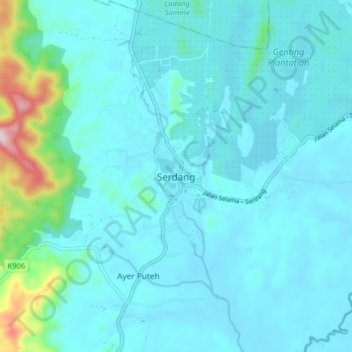
Name: Serdang topographic map, elevation, terrain.
Location: Serdang, Bandar Baharu, Kedah, 09800, Malaysia (5.17013 100.57159 5.25013 100.65159)
Average elevation: 56 m
Minimum elevation: 2 m
Maximum elevation: 462 m
Other topographic maps
Click on a map to view its topography, its elevation and its terrain.
Pantai Johor
Malaysia > Kedah > Pantai Johor
Pantai Johor, Kota Setar, Kedah, 06550, Malaysia
Average elevation: 4 m
Padang Serai
Malaysia > Kedah > Padang Serai
Padang Serai, Kulim, Kedah, 09400, Malaysia
Average elevation: 13 m