
Make a donation
Gear up for your next adventure:
As an Amazon Associate, this site earns from qualifying purchases at no extra cost to you.
74080 topographic map
Click on the map to display elevation.
Make a donation
Gear up for your next adventure:
As an Amazon Associate, this site earns from qualifying purchases at no extra cost to you.
About this map
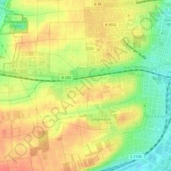
Name: 74080 topographic map, elevation, terrain.
Location: 74080, Böckingen, Heilbronn, Baden-Württemberg, Deutschland (49.11974 9.13021 49.15725 9.20288)
Average elevation: 182 m
Minimum elevation: 144 m
Maximum elevation: 221 m
Make a donation
Gear up for your next adventure:
As an Amazon Associate, this site earns from qualifying purchases at no extra cost to you.
Other topographic maps
Click on a map to view its topography, its elevation and its terrain.
Heilbronn
Deutschland > Baden-Württemberg > Heilbronn
Die nicht von Flussablagerungen bedeckten Heilbronner Berge im Osten des Stadtgebietes spiegeln die weitere geologische Schichtenabfolge wider, die im übrigen Stadtgebiet durch Erosion abgetragen wurde. Auf 28 bis 29 Metern Unterer Keuper folgen 130 bis 150 Meter Gipskeuper (Grabfeld-Formation) und eine etwa…
Average elevation: 255 m
Wartberg
Deutschland > Baden-Württemberg > Heilbronn
Die Höhe des Wartbergs (313,3 m) wird oftmals mit 308 m angegeben, was sich aber auf eine 307,6 m hohe Stelle etwa 100 m südöstlich seines am Wartbergturm liegenden Gipfels bezieht, teils aber auch mit 309 m.
Average elevation: 200 m
Make a donation
Gear up for your next adventure:
As an Amazon Associate, this site earns from qualifying purchases at no extra cost to you.