
Sable River topographic map
Interactive map
Click on the map to display elevation.
About this map
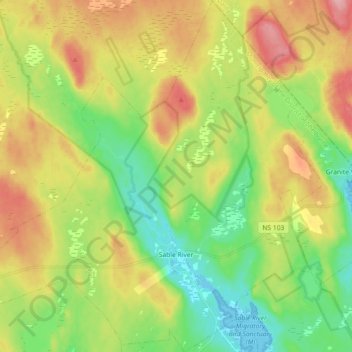
Name: Sable River topographic map, elevation, terrain.
Average elevation: 50 m
Minimum elevation: -1 m
Maximum elevation: 117 m
Other topographic maps
Click on a map to view its topography, its elevation and its terrain.
Shag Harbour
Canada > Nova Scotia > Shelburne County
Shag Harbour, Municipality of the District of Barrington, Shelburne County, Nova Scotia, B0W 3B0, Canada
Average elevation: 3 m
East Sable River
Canada > Nova Scotia > Shelburne County
East Sable River, Municipality of the District of Shelburne, Shelburne County, Nova Scotia, B0T 1V0, Canada
Average elevation: 17 m
Clam Creek
Canada > Nova Scotia > Shelburne County > Cape Negro
Clam Creek, Cape Negro, Municipality of the District of Barrington, Shelburne County, Nova Scotia, B0W 1K0, Canada
Average elevation: 2 m
Shag Harbour Pond
Canada > Nova Scotia > Shelburne County > Lower Shag Harbour
Shag Harbour Pond, Lower Shag Harbour, Municipality of the District of Barrington, Shelburne County, Nova Scotia, B0W 3B0, Canada
Average elevation: 11 m
Brook Islands
Canada > Nova Scotia > Shelburne County > Shag Harbour
Brook Islands, Shag Harbour, Municipality of the District of Barrington, Shelburne County, Nova Scotia, B0W 3B0, Canada
Average elevation: 9 m